Bastia geodata
Bastia (Veneto) is a seat of a third-order administrative division; located in Italy in Europe/Rome (GMT+2) time zone. With population of 1,802 people, there are 4484 cities with bigger population in this country. Compared to other cities in Italy, 69.9% of cities are located further ↓South; 51.2% of cities are located further ←West and 90.1% of cities have higher elevation than Bastia. Note1


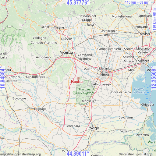
Bastia GPS coordinates[2]
45° 23' 9.924" North, 11° 39' 7.056" East
| Map corner | latitude | longitude |
|---|---|---|
| Upper-left | 45.87776°, | 10.94884° |
| Center: | 45.38609°, | 11.65196° |
| Lower-right: | 44.89011°, | 12.35509° |
| Map W x H: | 109.8×109.8 km | = 68.2×68.2mi |
| max Lat: | 47.04031° ⇑30.1% North |
| Bastia: | 45.38609° |
| min Lat: | ⇓69.9% South 35.50142° |
| min Long | Bastia | max Long |
| 6.69888° | 11.65196° | 18.48682° |
| W 51.2%⇐ | ⇒48.8% E |
Elevation
Elevation of Bastia is 18 m = 59 ft, and this is 288.7 m = 947 ft below average elevation for this country.
| Max E: |
2085 m = 6841 ft | 90.1% |
| Avg. | 306.7 m = 1006 ft | |
| Bastia | 18 m = 59 ft | |
Min E: |
-4 m = -13 ft | 9.9% |
See also: Italy elevation on elevation.city.
Geographical zone
Bastia is located in North temperate zone (between Tropic of Cancer and the Arctic Circle). Distance of this North polar circle is 2354.7 km =1463.1 mi to North.| Distance of | km | miles | from Bastia |
|---|---|---|---|
| North Pole | 4960.6 | 3082.4 | to North |
| Arctic Circle | 2354.7 | 1463.1 | to North |
| Tropic Cancer | 2440.5 | 1516.5 | to South |
| Equator | 5046.5 | 3135.7 | to South |


Nearby cities:
15 places around Bastia: (largest is in red/bold)
• Albettone
6.1 km =3.8 mi,  239°
239°
• Carbonara
2.6 km =1.6 mi,  207°
207°
• Cervarese Santa Croce
5.1 km =3.2 mi,  33°
33°
• Montegalda
6.9 km =4.3 mi,  15°
15°
• Montegaldella
5.9 km =3.7 mi,  14°
14°
• Montemerlo
4.4 km =2.7 mi,  98°
98°
• Ponte di Barbarano
5.8 km =3.6 mi,  276°
276°
• Ponte di Castegnero
6.9 km =4.3 mi,  324°
324°
• Ponte di Nanto
6.2 km =3.9 mi,  313°
313°
• Saccolongo
7.7 km =4.8 mi,  77°
77°
• San Biagio
6.8 km =4.2 mi, 100°
• San Marco
6.2 km =3.9 mi,  62°
62°
• Treponti
4.9 km =3 mi,  115°
115°
• Villaganzerla
6.1 km =3.8 mi,  334°
334°
• Vò
6.5 km =4 mi,  187°
187°
Sources, notices
• [Note1] Compared only with cities in Italy existing in our database
• [Src1] Map data: © OpenStreetMap contributors (CC-BY-SA)
• [Src2] Other city data from geonames.org with taken over terms of usage.
• [Src3] Geographical zone / Annual Mean Temperature by Robert A. Rohde @ Wikipedia
