Carbonara geodata
Carbonara (Veneto) is a populated place; located in Italy in Europe/Rome (GMT+2) time zone. With population of 580 people, there are 9180 cities with bigger population in this country. Compared to other cities in Italy, 69.3% of cities are located further ↓South; 51.1% of cities are located further ←West and 91.1% of cities have higher elevation than Carbonara. Note1


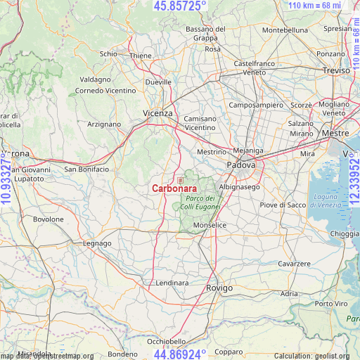
Carbonara GPS coordinates[2]
45° 21' 55.44" North, 11° 38' 11.004" East
| Map corner | latitude | longitude |
|---|---|---|
| Upper-left | 45.85725°, | 10.93327° |
| Center: | 45.3654°, | 11.63639° |
| Lower-right: | 44.86924°, | 12.33952° |
| Map W x H: | 109.9×109.9 km | = 68.3×68.3mi |
| max Lat: | 47.04031° ⇑30.7% North |
| Carbonara: | 45.3654° |
| min Lat: | ⇓69.3% South 35.50142° |
| min Long | Carbonara | max Long |
| 6.69888° | 11.63639° | 18.48682° |
| W 51.1%⇐ | ⇒48.9% E |
Elevation
Elevation of Carbonara is 16 m = 52 ft, and this is 290.7 m = 954 ft below average elevation for this country.
| Max E: |
2085 m = 6841 ft | 91.1% |
| Avg. | 306.7 m = 1006 ft | |
| Carbonara | 16 m = 52 ft | |
Min E: |
-4 m = -13 ft | 8.9% |
See also: Italy elevation on elevation.city.
Geographical zone
Carbonara is located in North temperate zone (between Tropic of Cancer and the Arctic Circle). Distance of this North polar circle is 2357 km =1464.6 mi to North.| Distance of | km | miles | from Carbonara |
|---|---|---|---|
| North Pole | 4962.9 | 3083.8 | to North |
| Arctic Circle | 2357 | 1464.6 | to North |
| Tropic Cancer | 2438.2 | 1515 | to South |
| Equator | 5044.2 | 3134.3 | to South |


Nearby cities:
15 places around Carbonara: (largest is in red/bold)
• Agugliaro
6 km =3.7 mi,  221°
221°
• Albettone
4.1 km =2.5 mi,  258°
258°
• Bastia
2.6 km =1.6 mi,  27°
27°
• Campiglia dei Berici
8.1 km =5 mi,  245°
245°
• Cervarese Santa Croce
7.7 km =4.8 mi, 31°
• Lozzo Atestino
8.3 km =5.2 mi,  197°
197°
• Montegaldella
8.4 km =5.2 mi,  18°
18°
• Montemerlo
5.8 km =3.6 mi,  73°
73°
• Ponte di Barbarano
5.4 km =3.4 mi,  303°
303°
• Ponte di Nanto
7.3 km =4.5 mi,  333°
333°
• San Biagio
7.9 km =4.9 mi,  82°
82°
• Torreglia
8.4 km =5.2 mi,  112°
112°
• Treponti
5.7 km =3.5 mi,  87°
87°
• Villaganzerla
8 km =5 mi,  349°
349°
• Vò
4.1 km =2.5 mi,  174°
174°
Sources, notices
• [Note1] Compared only with cities in Italy existing in our database
• [Src1] Map data: © OpenStreetMap contributors (CC-BY-SA)
• [Src2] Other city data from geonames.org with taken over terms of usage.
• [Src3] Geographical zone / Annual Mean Temperature by Robert A. Rohde @ Wikipedia
