Carifi-Torello-Priscoli geodata
Carifi-Torello-Priscoli (Campania) is a populated place; located in Italy in Europe/Rome (GMT+2) time zone. With population of 1,538 people, there are 5041 cities with bigger population in this country. Compared to other cities in Italy, 81.5% of cities are located further ↑North; 84.7% of cities are located further ←West and 59.9% of cities have higher elevation than Carifi-Torello-Priscoli. Note1
Administrative division(s):
- Level 1: Campania
- Level 2: Provincia di Salerno
- Level 3: Mercato San Severino
Current local time in Carifi-Torello-Priscoli:
11:17 PM, WednesdayDifference from your time zone: hours


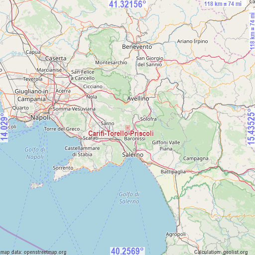
Carifi-Torello-Priscoli GPS coordinates[2]
40° 47' 28.896" North, 14° 43' 55.632" East
| Map corner | latitude | longitude |
|---|---|---|
| Upper-left | 41.32156°, | 14.029° |
| Center: | 40.79136°, | 14.73212° |
| Lower-right: | 40.2569°, | 15.43525° |
| Map W x H: | 118.4×118.4 km | = 73.6×73.6mi |
| max Lat: | 47.04031° ⇑81.5% North |
| Carifi-Torello-Priscoli: | 40.79136° |
| min Lat: | ⇓18.5% South 35.50142° |
| min Long | Carifi-Torello- | max Long |
| 6.69888° | 14.73212° | 18.48682° |
| W 84.7%⇐ | ⇒15.3% E |
Elevation
Elevation of Carifi-Torello-Priscoli is 164 m = 538 ft, and this is 142.7 m = 468 ft below average elevation for this country.
| Max E: |
2085 m = 6841 ft | 59.9% |
| Avg. | 306.7 m = 1006 ft | |
| Carifi-Torello-Priscoli | 164 m = 538 ft | |
Min E: |
-4 m = -13 ft | 40.1% |
See also: Italy elevation on elevation.city.
Geographical zone
Carifi-Torello-Priscoli is located in North temperate zone (between Tropic of Cancer and the Arctic Circle). Distance of this Northern Tropic circle is 1929.7 km =1199.1 mi to South.| Distance of | km | miles | from Carifi-Torello-Priscoli |
|---|---|---|---|
| North Pole | 5471.5 | 3399.8 | to North |
| Arctic Circle | 2865.6 | 1780.6 | to North |
| Tropic Cancer | 1929.7 | 1199.1 | to South |
| Equator | 4535.6 | 2818.3 | to South |


Nearby cities:
15 places around Carifi-Torello-Priscoli: (largest is in red/bold)
• Acquarola
2.6 km =1.6 mi,  192°
192°
• Bracigliano
3.7 km =2.3 mi,  326°
326°
• Castel San Giorgio
2.8 km =1.7 mi,  248°
248°
• Ciorani
1.5 km =0.9 mi,  359°
359°
• Faraldo-Nocelleto
2.9 km =1.8 mi,  115°
115°
• Le Selve
4.5 km =2.8 mi,  114°
114°
• Mercato San Severino
2 km =1.2 mi, 112°
• Piano
4 km =2.5 mi,  35°
35°
• Piazza del Galdo-Sant'Angelo
2.3 km =1.4 mi,  213°
213°
• Piazza di Pandola
3.8 km =2.4 mi,  61°
61°
• Pizzolano
4.3 km =2.7 mi,  103°
103°
• Roccapiemonte
4.9 km =3 mi,  224°
224°
• Siano
3.5 km =2.2 mi,  290°
290°
• Soccorso
3.5 km =2.2 mi,  80°
80°
• Spiano
3.6 km =2.2 mi,  155°
155°
Sources, notices
• [Note1] Compared only with cities in Italy existing in our database
• [Src1] Map data: © OpenStreetMap contributors (CC-BY-SA)
• [Src2] Other city data from geonames.org with taken over terms of usage.
• [Src3] Geographical zone / Annual Mean Temperature by Robert A. Rohde @ Wikipedia
