Siano geodata
Siano (Campania) is a seat of a third-order administrative division; located in Italy in Europe/Rome (GMT+2) time zone. With population of 9,855 people, there are 962 cities with bigger population in this country. Compared to other cities in Italy, 81.4% of cities are located further ↑North; 84.4% of cities are located further ←West and 64.5% of cities have higher elevation than Siano. Note1


Siano GPS coordinates[2]
40° 48' 7.452" North, 14° 41' 36.024" East
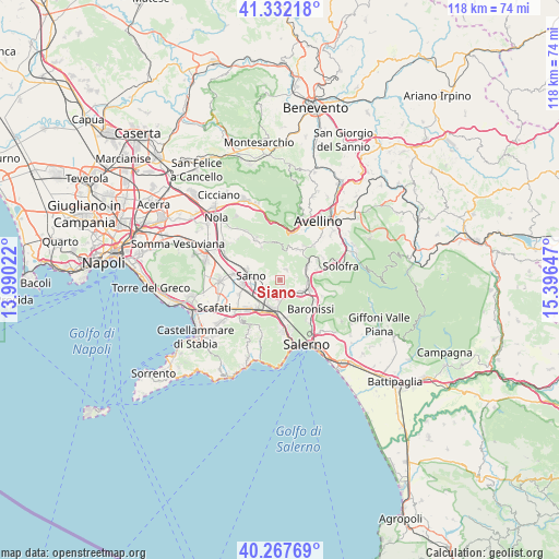
| Map corner | latitude | longitude |
|---|---|---|
| Upper-left | 41.33218°, | 13.99022° |
| Center: | 40.80207°, | 14.69334° |
| Lower-right: | 40.26769°, | 15.39647° |
| Map W x H: | 118.4×118.4 km | = 73.6×73.6mi |
| max Lat: | 47.04031° ⇑81.4% North |
| Siano: | 40.80207° |
| min Lat: | ⇓18.6% South 35.50142° |
| min Long | Siano | max Long |
| 6.69888° | 14.69334° | 18.48682° |
| W 84.4%⇐ | ⇒15.6% E |
Elevation
Elevation of Siano is 131 m = 430 ft, and this is 175.7 m = 576 ft below average elevation for this country.
| Max E: |
2085 m = 6841 ft | 64.5% |
| Avg. | 306.7 m = 1006 ft | |
| Siano | 131 m = 430 ft | |
Min E: |
-4 m = -13 ft | 35.5% |
See also: Italy elevation on elevation.city.
Geographical zone
Siano is located in North temperate zone (between Tropic of Cancer and the Arctic Circle). Distance of this Northern Tropic circle is 1930.8 km =1199.7 mi to South.| Distance of | km | miles | from Siano |
|---|---|---|---|
| North Pole | 5470.3 | 3399.1 | to North |
| Arctic Circle | 2864.4 | 1779.9 | to North |
| Tropic Cancer | 1930.8 | 1199.7 | to South |
| Equator | 4536.8 | 2819 | to South |


Nearby cities:
15 places around Siano: (largest is in red/bold)
• Acquarola
4.6 km =2.9 mi,  144°
144°
• Bracigliano
2.2 km =1.4 mi,  33°
33°
• Carifi-Torello-Priscoli
3.5 km =2.2 mi,  110°
110°
• Casali-San Potito
4.5 km =2.8 mi,  199°
199°
• Castel San Giorgio
2.3 km =1.4 mi,  164°
164°
• Ciorani
3.3 km =2.1 mi,  83°
83°
• Faraldo-Nocelleto
6.4 km =4 mi, 112°
• Lanzara
3.4 km =2.1 mi,  205°
205°
• Mercato San Severino
5.4 km =3.4 mi, 110°
• Piano
6 km =3.7 mi,  69°
69°
• Piazza del Galdo-Sant'Angelo
3.7 km =2.3 mi,  147°
147°
• Piazza di Pandola
6.6 km =4.1 mi, 84°
• Roccapiemonte
4.7 km =2.9 mi,  182°
182°
• Sarno
6.1 km =3.8 mi,  275°
275°
• Spiano
6.6 km =4.1 mi,  133°
133°
Sources, notices
• [Note1] Compared only with cities in Italy existing in our database
• [Src1] Map data: © OpenStreetMap contributors (CC-BY-SA)
• [Src2] Other city data from geonames.org with taken over terms of usage.
• [Src3] Geographical zone / Annual Mean Temperature by Robert A. Rohde @ Wikipedia
