Barberi geodata
Barberi (Abruzzo) is a populated place; located in Italy in Europe/Rome (GMT+2) time zone. With population of 1,244 people, there are 5812 cities with bigger population in this country. Compared to other cities in Italy, 66.6% of cities are located further ↑North; 78.5% of cities are located further ←West and 72.2% of cities have higher elevation than Barberi. Note1


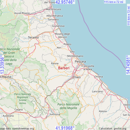
Barberi GPS coordinates[2]
42° 26' 26.592" North, 14° 2' 33.648" East
| Map corner | latitude | longitude |
|---|---|---|
| Upper-left | 42.95746°, | 13.33956° |
| Center: | 42.44072°, | 14.04268° |
| Lower-right: | 41.91968°, | 14.74581° |
| Map W x H: | 115.4×115.4 km | = 71.7×71.7mi |
| max Lat: | 47.04031° ⇑66.6% North |
| Barberi: | 42.44072° |
| min Lat: | ⇓33.4% South 35.50142° |
| min Long | Barberi | max Long |
| 6.69888° | 14.04268° | 18.48682° |
| W 78.5%⇐ | ⇒21.5% E |
Elevation
Elevation of Barberi is 87 m = 285 ft, and this is 219.7 m = 721 ft below average elevation for this country.
| Max E: |
2085 m = 6841 ft | 72.2% |
| Avg. | 306.7 m = 1006 ft | |
| Barberi | 87 m = 285 ft | |
Min E: |
-4 m = -13 ft | 27.8% |
See also: Italy elevation on elevation.city.
Geographical zone
Barberi is located in North temperate zone (between Tropic of Cancer and the Arctic Circle). Distance of this Northern Tropic circle is 2113 km =1313 mi to South.| Distance of | km | miles | from Barberi |
|---|---|---|---|
| North Pole | 5288.1 | 3285.9 | to North |
| Arctic Circle | 2682.2 | 1666.6 | to North |
| Tropic Cancer | 2113 | 1313 | to South |
| Equator | 4719 | 2932.2 | to South |


Nearby cities:
15 places around Barberi: (largest is in red/bold)
• Cappelle sul Tavo
6.7 km =4.2 mi,  52°
52°
• Caprara d'Abruzzo
5.6 km =3.5 mi,  99°
99°
• Castellana
7.1 km =4.4 mi,  131°
131°
• Cepagatti
8.8 km =5.5 mi,  162°
162°
• Cerratina
7.5 km =4.7 mi,  138°
138°
• Città Sant'Angelo
8.1 km =5 mi,  11°
11°
• Collecorvino
3.1 km =1.9 mi,  314°
314°
• Congiunti
4.9 km =3 mi, 45°
• Loreto Aprutino
5.2 km =3.2 mi,  258°
258°
• Moscufo
1.8 km =1.1 mi,  147°
147°
• Pianella
4.6 km =2.9 mi,  174°
174°
• Picciano
5.8 km =3.6 mi, 311°
• Santa Teresa
9.6 km =6 mi, 98°
• Spoltore
8.1 km =5 mi,  78°
78°
• Villanova
9.3 km =5.8 mi, 134°
Sources, notices
• [Note1] Compared only with cities in Italy existing in our database
• [Src1] Map data: © OpenStreetMap contributors (CC-BY-SA)
• [Src2] Other city data from geonames.org with taken over terms of usage.
• [Src3] Geographical zone / Annual Mean Temperature by Robert A. Rohde @ Wikipedia
