Congiunti geodata
Congiunti (Abruzzo) is a populated place; located in Italy in Europe/Rome (GMT+2) time zone. With population of 755 people, there are 7914 cities with bigger population in this country. Compared to other cities in Italy, 66.4% of cities are located further ↑North; 78.8% of cities are located further ←West and 82.5% of cities have higher elevation than Congiunti. Note1


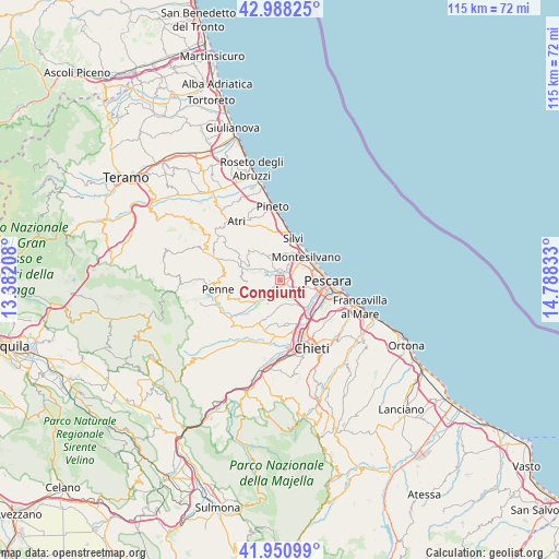
Congiunti GPS coordinates[2]
42° 28' 18.372" North, 14° 5' 6.72" East
| Map corner | latitude | longitude |
|---|---|---|
| Upper-left | 42.98825°, | 13.38208° |
| Center: | 42.47177°, | 14.0852° |
| Lower-right: | 41.95099°, | 14.78833° |
| Map W x H: | 115.3×115.3 km | = 71.6×71.6mi |
| max Lat: | 47.04031° ⇑66.4% North |
| Congiunti: | 42.47177° |
| min Lat: | ⇓33.6% South 35.50142° |
| min Long | Congiunti | max Long |
| 6.69888° | 14.0852° | 18.48682° |
| W 78.8%⇐ | ⇒21.2% E |
Elevation
Elevation of Congiunti is 40 m = 131 ft, and this is 266.7 m = 875 ft below average elevation for this country.
| Max E: |
2085 m = 6841 ft | 82.5% |
| Avg. | 306.7 m = 1006 ft | |
| Congiunti | 40 m = 131 ft | |
Min E: |
-4 m = -13 ft | 17.5% |
See also: Italy elevation on elevation.city.
Geographical zone
Congiunti is located in North temperate zone (between Tropic of Cancer and the Arctic Circle). Distance of this Northern Tropic circle is 2116.5 km =1315.1 mi to South.| Distance of | km | miles | from Congiunti |
|---|---|---|---|
| North Pole | 5284.6 | 3283.7 | to North |
| Arctic Circle | 2678.8 | 1664.5 | to North |
| Tropic Cancer | 2116.5 | 1315.1 | to South |
| Equator | 4722.4 | 2934.4 | to South |


Nearby cities:
15 places around Congiunti: (largest is in red/bold)
• Barberi
4.9 km =3 mi,  225°
225°
• Cappelle sul Tavo
1.9 km =1.2 mi,  71°
71°
• Caprara d'Abruzzo
4.8 km =3 mi,  154°
154°
• Castellana
8.3 km =5.2 mi,  167°
167°
• Città Sant'Angelo
4.9 km =3 mi,  337°
337°
• Collecorvino
5.8 km =3.6 mi,  257°
257°
• Fonte Umano-San Martino Alta
5.8 km =3.6 mi,  18°
18°
• Montesilvano Colle
5.3 km =3.3 mi, 66°
• Montesilvano Marina
6.6 km =4.1 mi,  48°
48°
• Moscufo
5.6 km =3.5 mi,  207°
207°
• Picciano
7.8 km =4.8 mi,  272°
272°
• San Martino Bassa
6.4 km =4 mi,  35°
35°
• Santa Teresa
7.7 km =4.8 mi,  129°
129°
• Spoltore
4.9 km =3 mi,  112°
112°
• Villa Raspa
8.4 km =5.2 mi,  102°
102°
Sources, notices
• [Note1] Compared only with cities in Italy existing in our database
• [Src1] Map data: © OpenStreetMap contributors (CC-BY-SA)
• [Src2] Other city data from geonames.org with taken over terms of usage.
• [Src3] Geographical zone / Annual Mean Temperature by Robert A. Rohde @ Wikipedia
