Pietre geodata
Pietre (Campania) is a populated place; located in Italy in Europe/Rome (GMT+2) time zone. With population of 1,237 people, there are 5840 cities with bigger population in this country. Compared to other cities in Italy, 82.4% of cities are located further ↑North; 83.8% of cities are located further ←West and 70.5% of cities have lower elevation than Pietre. Note1


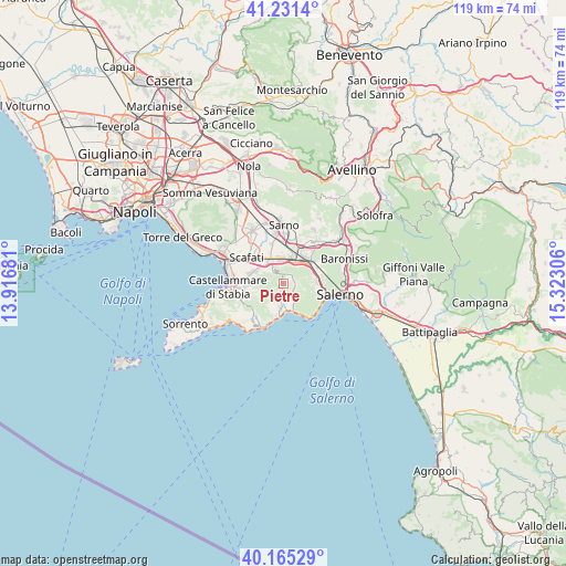
Pietre GPS coordinates[2]
40° 42' 1.728" North, 14° 37' 11.748" East
| Map corner | latitude | longitude |
|---|---|---|
| Upper-left | 41.2314°, | 13.91681° |
| Center: | 40.70048°, | 14.61993° |
| Lower-right: | 40.16529°, | 15.32306° |
| Map W x H: | 118.5×118.5 km | = 73.6×73.6mi |
| max Lat: | 47.04031° ⇑82.4% North |
| Pietre: | 40.70048° |
| min Lat: | ⇓17.6% South 35.50142° |
| min Long | Pietre | max Long |
| 6.69888° | 14.61993° | 18.48682° |
| W 83.8%⇐ | ⇒16.2% E |
Elevation
Elevation of Pietre is 399 m = 1309 ft, and this is 92.3 m = 303 ft above average elevation for this country.
| Max E: |
2085 m = 6841 ft | 29.5% |
| Pietre | 399 m 1309 ft | |
| Avg. | 306.7 m = 1006 ft | |
Min E: |
-4 m = -13 ft | 70.5% |
See also: Italy elevation on elevation.city.
Geographical zone
Pietre is located in North temperate zone (between Tropic of Cancer and the Arctic Circle). Distance of this Northern Tropic circle is 1919.6 km =1192.8 mi to South.| Distance of | km | miles | from Pietre |
|---|---|---|---|
| North Pole | 5481.6 | 3406.1 | to North |
| Arctic Circle | 2875.7 | 1786.9 | to North |
| Tropic Cancer | 1919.6 | 1192.8 | to South |
| Equator | 4525.5 | 2812 | to South |


Nearby cities:
15 places around Pietre: (largest is in red/bold)
• Angri
5.9 km =3.7 mi,  315°
315°
• Campinola
2.1 km =1.3 mi,  78°
78°
• Corbara
3.4 km =2.1 mi, 316°
• Corpo di Cava
6.2 km =3.9 mi,  108°
108°
• Lettere
6.3 km =3.9 mi,  274°
274°
• Maiori
6 km =3.7 mi,  163°
163°
• Minori
5.6 km =3.5 mi,  174°
174°
• Nocera Inferiore
5.4 km =3.4 mi,  23°
23°
• Pagani
4.6 km =2.9 mi,  354°
354°
• Piazza Roma
6.5 km =4 mi, 273°
• Polvica
1.8 km =1.1 mi, 110°
• Ravello
5.7 km =3.5 mi,  186°
186°
• Sant'Egidio del Monte Albino
4.8 km =3 mi,  333°
333°
• Scala
5 km =3.1 mi, 192°
• Tramonti
2.3 km =1.4 mi,  115°
115°
Sources, notices
• [Note1] Compared only with cities in Italy existing in our database
• [Src1] Map data: © OpenStreetMap contributors (CC-BY-SA)
• [Src2] Other city data from geonames.org with taken over terms of usage.
• [Src3] Geographical zone / Annual Mean Temperature by Robert A. Rohde @ Wikipedia
