Maiori geodata
Maiori (Campania) is a seat of a third-order administrative division; located in Italy in Europe/Rome (GMT+2) time zone. With population of 5,268 people, there are 1854 cities with bigger population in this country. Compared to other cities in Italy, 83% of cities are located further ↑North; 84% of cities are located further ←West and 92.6% of cities have higher elevation than Maiori. Note1


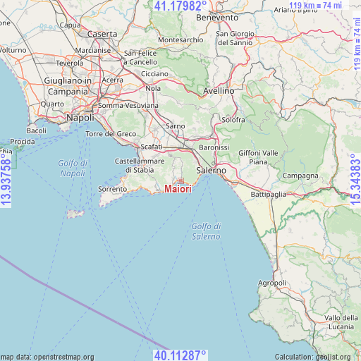
Maiori GPS coordinates[2]
40° 38' 54.528" North, 14° 38' 26.52" East
| Map corner | latitude | longitude |
|---|---|---|
| Upper-left | 41.17982°, | 13.93758° |
| Center: | 40.64848°, | 14.6407° |
| Lower-right: | 40.11287°, | 15.34383° |
| Map W x H: | 118.6×118.6 km | = 73.7×73.7mi |
| max Lat: | 47.04031° ⇑83% North |
| Maiori: | 40.64848° |
| min Lat: | ⇓17% South 35.50142° |
| min Long | Maiori | max Long |
| 6.69888° | 14.6407° | 18.48682° |
| W 84%⇐ | ⇒16% E |
Elevation
Elevation of Maiori is 13 m = 43 ft, and this is 293.7 m = 964 ft below average elevation for this country.
| Max E: |
2085 m = 6841 ft | 92.6% |
| Avg. | 306.7 m = 1006 ft | |
| Maiori | 13 m = 43 ft | |
Min E: |
-4 m = -13 ft | 7.4% |
See also: Italy elevation on elevation.city.
Geographical zone
Maiori is located in North temperate zone (between Tropic of Cancer and the Arctic Circle). Distance of this Northern Tropic circle is 1913.8 km =1189.2 mi to South.| Distance of | km | miles | from Maiori |
|---|---|---|---|
| North Pole | 5487.4 | 3409.7 | to North |
| Arctic Circle | 2881.5 | 1790.5 | to North |
| Tropic Cancer | 1913.8 | 1189.2 | to South |
| Equator | 4519.7 | 2808.4 | to South |


Nearby cities:
15 places around Maiori: (largest is in red/bold)
• Amalfi
3.6 km =2.2 mi,  244°
244°
• Atrani
3 km =1.9 mi, 242°
• Campinola
6.2 km =3.9 mi,  2°
2°
• Cetara
5.1 km =3.2 mi,  91°
91°
• Conca dei Marini
6.7 km =4.2 mi, 238°
• Corpo di Cava
5.6 km =3.5 mi,  46°
46°
• Dragonea
6.8 km =4.2 mi,  60°
60°
• Minori
1.2 km =0.7 mi,  279°
279°
• Pietre
6 km =3.7 mi,  343°
343°
• Polvica
5.2 km =3.2 mi,  359°
359°
• Raito
6.9 km =4.3 mi,  70°
70°
• Ravello
2.5 km =1.6 mi,  272°
272°
• Scala
2.9 km =1.8 mi,  288°
288°
• Tramonti
4.8 km =3 mi, 4°
• Vietri sul Mare
7.6 km =4.7 mi, 71°
Sources, notices
• [Note1] Compared only with cities in Italy existing in our database
• [Src1] Map data: © OpenStreetMap contributors (CC-BY-SA)
• [Src2] Other city data from geonames.org with taken over terms of usage.
• [Src3] Geographical zone / Annual Mean Temperature by Robert A. Rohde @ Wikipedia
