Campinola geodata
Campinola (Campania) is a populated place; located in Italy in Europe/Rome (GMT+2) time zone. With population of 855 people, there are 7383 cities with bigger population in this country. Compared to other cities in Italy, 82.4% of cities are located further ↑North; 84% of cities are located further ←West and 70.2% of cities have lower elevation than Campinola. Note1


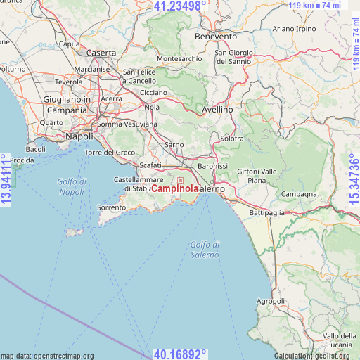
Campinola GPS coordinates[2]
40° 42' 14.688" North, 14° 38' 39.228" East
| Map corner | latitude | longitude |
|---|---|---|
| Upper-left | 41.23498°, | 13.94111° |
| Center: | 40.70408°, | 14.64423° |
| Lower-right: | 40.16892°, | 15.34736° |
| Map W x H: | 118.5×118.5 km | = 73.6×73.6mi |
| max Lat: | 47.04031° ⇑82.4% North |
| Campinola: | 40.70408° |
| min Lat: | ⇓17.6% South 35.50142° |
| min Long | Campinola | max Long |
| 6.69888° | 14.64423° | 18.48682° |
| W 84%⇐ | ⇒16% E |
Elevation
Elevation of Campinola is 396 m = 1299 ft, and this is 89.3 m = 293 ft above average elevation for this country.
| Max E: |
2085 m = 6841 ft | 29.8% |
| Campinola | 396 m 1299 ft | |
| Avg. | 306.7 m = 1006 ft | |
Min E: |
-4 m = -13 ft | 70.2% |
See also: Italy elevation on elevation.city.
Geographical zone
Campinola is located in North temperate zone (between Tropic of Cancer and the Arctic Circle). Distance of this Northern Tropic circle is 1920 km =1193 mi to South.| Distance of | km | miles | from Campinola |
|---|---|---|---|
| North Pole | 5481.2 | 3405.9 | to North |
| Arctic Circle | 2875.3 | 1786.6 | to North |
| Tropic Cancer | 1920 | 1193 | to South |
| Equator | 4525.9 | 2812.3 | to South |


Nearby cities:
15 places around Campinola: (largest is in red/bold)
• Cava Dè Tirreni
5.4 km =3.4 mi,  95°
95°
• Corbara
4.9 km =3 mi,  295°
295°
• Corpo di Cava
4.5 km =2.8 mi,  121°
121°
• Dragonea
6.3 km =3.9 mi, 116°
• Maiori
6.2 km =3.9 mi,  182°
182°
• Minori
6.2 km =3.9 mi,  193°
193°
• Nocera Inferiore
4.6 km =2.9 mi,  1°
1°
• Nocera Superiore
5 km =3.1 mi,  30°
30°
• Pagani
4.9 km =3 mi,  329°
329°
• Pietre
2.1 km =1.3 mi,  258°
258°
• Polvica
1.1 km =0.7 mi,  198°
198°
• Sant'Anna I
6.5 km =4 mi,  60°
60°
• Sant'Egidio del Monte Albino
5.7 km =3.5 mi,  312°
312°
• Scala
6.1 km =3.8 mi,  210°
210°
• Tramonti
1.4 km =0.9 mi, 177°
Sources, notices
• [Note1] Compared only with cities in Italy existing in our database
• [Src1] Map data: © OpenStreetMap contributors (CC-BY-SA)
• [Src2] Other city data from geonames.org with taken over terms of usage.
• [Src3] Geographical zone / Annual Mean Temperature by Robert A. Rohde @ Wikipedia
