Brezza geodata
Brezza (Campania) is a populated place; located in Italy in Europe/Rome (GMT+2) time zone. With population of 1,041 people, there are 6500 cities with bigger population in this country. Compared to other cities in Italy, 77.4% of cities are located further ↑North; 79.1% of cities are located further ←West and 91.1% of cities have higher elevation than Brezza. Note1


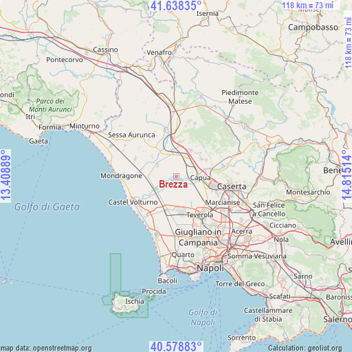
Brezza GPS coordinates[2]
41° 6' 38.628" North, 14° 6' 43.236" East
| Map corner | latitude | longitude |
|---|---|---|
| Upper-left | 41.63835°, | 13.40889° |
| Center: | 41.11073°, | 14.11201° |
| Lower-right: | 40.57883°, | 14.81514° |
| Map W x H: | 117.8×117.8 km | = 73.2×73.2mi |
| max Lat: | 47.04031° ⇑77.4% North |
| Brezza: | 41.11073° |
| min Lat: | ⇓22.6% South 35.50142° |
| min Long | Brezza | max Long |
| 6.69888° | 14.11201° | 18.48682° |
| W 79.1%⇐ | ⇒20.9% E |
Elevation
Elevation of Brezza is 16 m = 52 ft, and this is 290.7 m = 954 ft below average elevation for this country.
| Max E: |
2085 m = 6841 ft | 91.1% |
| Avg. | 306.7 m = 1006 ft | |
| Brezza | 16 m = 52 ft | |
Min E: |
-4 m = -13 ft | 8.9% |
See also: Italy elevation on elevation.city.
Geographical zone
Brezza is located in North temperate zone (between Tropic of Cancer and the Arctic Circle). Distance of this Northern Tropic circle is 1965.2 km =1221.1 mi to South.| Distance of | km | miles | from Brezza |
|---|---|---|---|
| North Pole | 5436 | 3377.8 | to North |
| Arctic Circle | 2830.1 | 1758.5 | to North |
| Tropic Cancer | 1965.2 | 1221.1 | to South |
| Equator | 4571.1 | 2840.3 | to South |


Nearby cities:
15 places around Brezza: (largest is in red/bold)
• Camigliano
11.3 km =7 mi,  46°
46°
• Cancello ed Arnone
8.3 km =5.2 mi,  239°
239°
• Cancello-Arnone
8.4 km =5.2 mi, 240°
• Capua
8.5 km =5.3 mi,  94°
94°
• Casal di Principe
11.3 km =7 mi,  172°
172°
• Francolise
9.5 km =5.9 mi,  330°
330°
• Grazzanise
2.6 km =1.6 mi,  205°
205°
• Nocelleto
10.5 km =6.5 mi,  309°
309°
• Pastorano
10.6 km =6.6 mi,  42°
42°
• Pignataro Maggiore
10.1 km =6.3 mi,  28°
28°
• San Tammaro
10.7 km =6.6 mi,  111°
111°
• Sant'Andrea-Pizzone-Ciamprisco
7.9 km =4.9 mi,  303°
303°
• Santa Maria la Fossa
2.5 km =1.6 mi,  147°
147°
• Sparanise
8.7 km =5.4 mi,  351°
351°
• Vitulazio
10.3 km =6.4 mi,  55°
55°
Sources, notices
• [Note1] Compared only with cities in Italy existing in our database
• [Src1] Map data: © OpenStreetMap contributors (CC-BY-SA)
• [Src2] Other city data from geonames.org with taken over terms of usage.
• [Src3] Geographical zone / Annual Mean Temperature by Robert A. Rohde @ Wikipedia
