Sforzacosta geodata
Sforzacosta (The Marches) is a populated place; located in Italy in Europe/Rome (GMT+2) time zone. With population of 2,102 people, there are 3982 cities with bigger population in this country. Compared to other cities in Italy, 61.5% of cities are located further ↑North; 72.6% of cities are located further ←West and 64.2% of cities have higher elevation than Sforzacosta. Note1


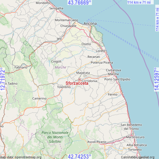
Sforzacosta GPS coordinates[2]
43° 15' 24.336" North, 13° 25' 22.224" East
| Map corner | latitude | longitude |
|---|---|---|
| Upper-left | 43.76669°, | 12.71972° |
| Center: | 43.25676°, | 13.42284° |
| Lower-right: | 42.74253°, | 14.12597° |
| Map W x H: | 113.9×113.9 km | = 70.8×70.8mi |
| max Lat: | 47.04031° ⇑61.5% North |
| Sforzacosta: | 43.25676° |
| min Lat: | ⇓38.5% South 35.50142° |
| min Long | Sforzacosta | max Long |
| 6.69888° | 13.42284° | 18.48682° |
| W 72.6%⇐ | ⇒27.4% E |
Elevation
Elevation of Sforzacosta is 133 m = 436 ft, and this is 173.7 m = 570 ft below average elevation for this country.
| Max E: |
2085 m = 6841 ft | 64.2% |
| Avg. | 306.7 m = 1006 ft | |
| Sforzacosta | 133 m = 436 ft | |
Min E: |
-4 m = -13 ft | 35.8% |
See also: Italy elevation on elevation.city.
Geographical zone
Sforzacosta is located in North temperate zone (between Tropic of Cancer and the Arctic Circle). Distance of this Northern Tropic circle is 2203.8 km =1369.4 mi to South.| Distance of | km | miles | from Sforzacosta |
|---|---|---|---|
| North Pole | 5197.4 | 3229.5 | to North |
| Arctic Circle | 2591.5 | 1610.3 | to North |
| Tropic Cancer | 2203.8 | 1369.4 | to South |
| Equator | 4809.7 | 2988.6 | to South |


Nearby cities:
15 places around Sforzacosta: (largest is in red/bold)
• Casette Verdini
1.8 km =1.1 mi,  249°
249°
• Corridonia
6.9 km =4.3 mi,  99°
99°
• Loro Piceno
10.3 km =6.4 mi,  185°
185°
• Macerata
5.2 km =3.2 mi,  28°
28°
• Mogliano
9.5 km =5.9 mi,  144°
144°
• Passo del Bidollo
0.9 km =0.6 mi,  176°
176°
• Passo di Treia
8 km =5 mi,  294°
294°
• Petriolo
5 km =3.1 mi, 141°
• Piediripa
5.7 km =3.5 mi,  66°
66°
• Pollenza
6.2 km =3.9 mi,  279°
279°
• San Claudio
6.8 km =4.2 mi, 72°
• Sant'Egidio
10.4 km =6.5 mi,  15°
15°
• Urbisaglia
8.1 km =5 mi,  208°
208°
• Villa Potenza
7.2 km =4.5 mi,  2°
2°
• Zona Industriale
5.3 km =3.3 mi,  84°
84°
Sources, notices
• [Note1] Compared only with cities in Italy existing in our database
• [Src1] Map data: © OpenStreetMap contributors (CC-BY-SA)
• [Src2] Other city data from geonames.org with taken over terms of usage.
• [Src3] Geographical zone / Annual Mean Temperature by Robert A. Rohde @ Wikipedia
