Ortomatera geodata
Ortomatera (Calabria) is a populated place; located in Italy in Europe/Rome (GMT+2) time zone. With population of 941 people, there are 6917 cities with bigger population in this country. Compared to other cities in Italy, 91.1% of cities are located further ↑North; 94.5% of cities are located further ←West and 50.9% of cities have lower elevation than Ortomatera. Note1


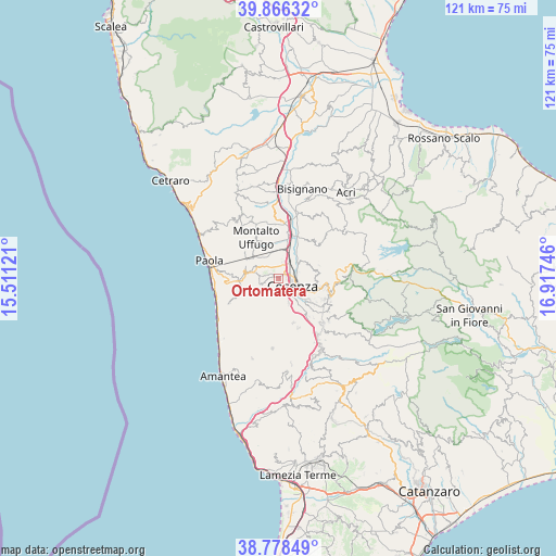
Ortomatera GPS coordinates[2]
39° 19' 28.272" North, 16° 12' 51.588" East
| Map corner | latitude | longitude |
|---|---|---|
| Upper-left | 39.86632°, | 15.51121° |
| Center: | 39.32452°, | 16.21433° |
| Lower-right: | 38.77849°, | 16.91746° |
| Map W x H: | 121×121 km | = 75.2×75.2mi |
| max Lat: | 47.04031° ⇑91.1% North |
| Ortomatera: | 39.32452° |
| min Lat: | ⇓8.9% South 35.50142° |
| min Long | Ortomatera | max Long |
| 6.69888° | 16.21433° | 18.48682° |
| W 94.5%⇐ | ⇒5.5% E |
Elevation
Elevation of Ortomatera is 240 m = 787 ft, and this is 66.7 m = 219 ft below average elevation for this country.
| Max E: |
2085 m = 6841 ft | 49.1% |
| Avg. | 306.7 m = 1006 ft | |
| Ortomatera | 240 m = 787 ft | |
Min E: |
-4 m = -13 ft | 50.9% |
See also: Italy elevation on elevation.city.
Geographical zone
Ortomatera is located in North temperate zone (between Tropic of Cancer and the Arctic Circle). Distance of this Northern Tropic circle is 1766.6 km =1097.7 mi to South.| Distance of | km | miles | from Ortomatera |
|---|---|---|---|
| North Pole | 5634.6 | 3501.2 | to North |
| Arctic Circle | 3028.7 | 1881.9 | to North |
| Tropic Cancer | 1766.6 | 1097.7 | to South |
| Equator | 4372.5 | 2716.9 | to South |


Nearby cities:
15 places around Ortomatera: (largest is in red/bold)
• Andreotta
1.9 km =1.2 mi,  171°
171°
• Arcavacata
3.8 km =2.4 mi,  352°
352°
• Castrolibero
2.3 km =1.4 mi,  226°
226°
• Cosenza
4.4 km =2.7 mi,  130°
130°
• Fontanesi-Santa Lucia
3.3 km =2.1 mi,  217°
217°
• Marano Marchesato
3.7 km =2.3 mi,  249°
249°
• Marano Principato
4.5 km =2.8 mi, 229°
• Quattromiglia
3 km =1.9 mi,  42°
42°
• Rende
3 km =1.9 mi,  284°
284°
• Rosario
4 km =2.5 mi,  158°
158°
• Santo Stefano
2.9 km =1.8 mi,  332°
332°
• Serra Miceli
2.4 km =1.5 mi,  207°
207°
• Surdo
1.2 km =0.7 mi,  286°
286°
• Tivolille Pasquali-Merenzata
5 km =3.1 mi,  186°
186°
• Vadue
5 km =3.1 mi, 165°
Sources, notices
• [Note1] Compared only with cities in Italy existing in our database
• [Src1] Map data: © OpenStreetMap contributors (CC-BY-SA)
• [Src2] Other city data from geonames.org with taken over terms of usage.
• [Src3] Geographical zone / Annual Mean Temperature by Robert A. Rohde @ Wikipedia
