Cadriano geodata
Cadriano (Emilia-Romagna) is a populated place; located in Italy in Europe/Rome (GMT+2) time zone. With population of 901 people, there are 7146 cities with bigger population in this country. Compared to other cities in Italy, 51.7% of cities are located further ↓South; 52% of cities are located further →East and 85% of cities have higher elevation than Cadriano. Note1


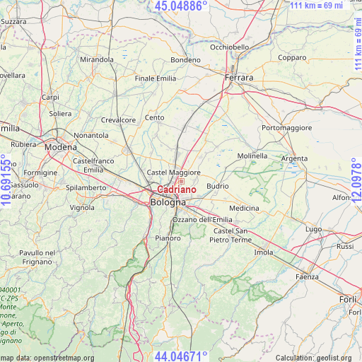
Cadriano GPS coordinates[2]
44° 32' 59.784" North, 11° 23' 40.812" East
| Map corner | latitude | longitude |
|---|---|---|
| Upper-left | 45.04886°, | 10.69155° |
| Center: | 44.54994°, | 11.39467° |
| Lower-right: | 44.04671°, | 12.0978° |
| Map W x H: | 111.4×111.4 km | = 69.2×69.2mi |
| max Lat: | 47.04031° ⇑48.3% North |
| Cadriano: | 44.54994° |
| min Lat: | ⇓51.7% South 35.50142° |
| min Long | Cadriano | max Long |
| 6.69888° | 11.39467° | 18.48682° |
| W 48%⇐ | ⇒52% E |
Elevation
Elevation of Cadriano is 31 m = 102 ft, and this is 275.7 m = 905 ft below average elevation for this country.
| Max E: |
2085 m = 6841 ft | 85% |
| Avg. | 306.7 m = 1006 ft | |
| Cadriano | 31 m = 102 ft | |
Min E: |
-4 m = -13 ft | 15% |
See also: Italy elevation on elevation.city.
Geographical zone
Cadriano is located in North temperate zone (between Tropic of Cancer and the Arctic Circle). Distance of this Northern Tropic circle is 2347.6 km =1458.7 mi to South.| Distance of | km | miles | from Cadriano |
|---|---|---|---|
| North Pole | 5053.6 | 3140.2 | to North |
| Arctic Circle | 2447.7 | 1520.9 | to North |
| Tropic Cancer | 2347.6 | 1458.7 | to South |
| Equator | 4953.5 | 3078 | to South |


Nearby cities:
15 places around Cadriano: (largest is in red/bold)
• Bologna
7.7 km =4.8 mi,  215°
215°
• Castagnolo Minore
6.5 km =4 mi,  350°
350°
• Castel Maggiore
4 km =2.5 mi,  318°
318°
• Castenaso
7.1 km =4.4 mi,  124°
124°
• Granarolo dell'Emilia e Viadagola
3.8 km =2.4 mi,  84°
84°
• Longara
7.6 km =4.7 mi,  288°
288°
• Lovoleto
4.8 km =3 mi,  31°
31°
• Progresso
3.2 km =2 mi,  311°
311°
• Quarto Inferiore
2.7 km =1.7 mi,  140°
140°
• San Marino
6.4 km =4 mi,  19°
19°
• San Vitale Grande
8.2 km =5.1 mi,  268°
268°
• Stiatico
8.1 km =5 mi,  340°
340°
• Trebbo
6 km =3.7 mi,  276°
276°
• Villa Salina
3.4 km =2.1 mi, 278°
• Villanova
6.3 km =3.9 mi,  152°
152°
Sources, notices
• [Note1] Compared only with cities in Italy existing in our database
• [Src1] Map data: © OpenStreetMap contributors (CC-BY-SA)
• [Src2] Other city data from geonames.org with taken over terms of usage.
• [Src3] Geographical zone / Annual Mean Temperature by Robert A. Rohde @ Wikipedia
