Castenaso geodata
Castenaso (Emilia-Romagna) is a seat of a third-order administrative division; located in Italy in Europe/Rome (GMT+2) time zone. With population of 8,961 people, there are 1060 cities with bigger population in this country. Compared to other cities in Italy, 51.3% of cities are located further ↓South; 50.9% of cities are located further →East and 84.1% of cities have higher elevation than Castenaso. Note1


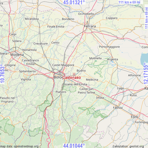
Castenaso GPS coordinates[2]
44° 30' 50.328" North, 11° 28' 6.312" East
| Map corner | latitude | longitude |
|---|---|---|
| Upper-left | 45.01321°, | 10.7653° |
| Center: | 44.51398°, | 11.46842° |
| Lower-right: | 44.01044°, | 12.17155° |
| Map W x H: | 111.5×111.5 km | = 69.3×69.3mi |
| max Lat: | 47.04031° ⇑48.7% North |
| Castenaso: | 44.51398° |
| min Lat: | ⇓51.3% South 35.50142° |
| min Long | Castenaso | max Long |
| 6.69888° | 11.46842° | 18.48682° |
| W 49.1%⇐ | ⇒50.9% E |
Elevation
Elevation of Castenaso is 34 m = 112 ft, and this is 272.7 m = 895 ft below average elevation for this country.
| Max E: |
2085 m = 6841 ft | 84.1% |
| Avg. | 306.7 m = 1006 ft | |
| Castenaso | 34 m = 112 ft | |
Min E: |
-4 m = -13 ft | 15.9% |
See also: Italy elevation on elevation.city.
Geographical zone
Castenaso is located in North temperate zone (between Tropic of Cancer and the Arctic Circle). Distance of this Northern Tropic circle is 2343.6 km =1456.2 mi to South.| Distance of | km | miles | from Castenaso |
|---|---|---|---|
| North Pole | 5057.6 | 3142.6 | to North |
| Arctic Circle | 2451.7 | 1523.4 | to North |
| Tropic Cancer | 2343.6 | 1456.2 | to South |
| Equator | 4949.5 | 3075.5 | to South |


Nearby cities:
15 places around Castenaso: (largest is in red/bold)
• Budrio
5.8 km =3.6 mi,  63°
63°
• Cadriano
7.1 km =4.4 mi,  304°
304°
• Granarolo dell'Emilia e Viadagola
4.8 km =3 mi,  335°
335°
• Lovoleto
8.7 km =5.4 mi, 337°
• Maggio
9 km =5.6 mi,  163°
163°
• Martiri di Pizzocalvo
9.1 km =5.7 mi,  218°
218°
• Ozzano dell'Emilia
7.8 km =4.8 mi,  175°
175°
• Ponte Rizzoli
6.4 km =4 mi,  148°
148°
• Ponticella
9.7 km =6 mi,  227°
227°
• Pulce
8.5 km =5.3 mi,  212°
212°
• Quarto Inferiore
4.5 km =2.8 mi,  294°
294°
• San Lazzaro
6.8 km =4.2 mi, 224°
• Vedrana
9.6 km =6 mi, 60°
• Villa Salina
10.3 km =6.4 mi, 295°
• Villanova
3.3 km =2.1 mi,  242°
242°
Sources, notices
• [Note1] Compared only with cities in Italy existing in our database
• [Src1] Map data: © OpenStreetMap contributors (CC-BY-SA)
• [Src2] Other city data from geonames.org with taken over terms of usage.
• [Src3] Geographical zone / Annual Mean Temperature by Robert A. Rohde @ Wikipedia
