Caldiero geodata
Caldiero (Veneto) is a seat of a third-order administrative division; located in Italy in Europe/Rome (GMT+2) time zone. With population of 5,743 people, there are 1711 cities with bigger population in this country. Compared to other cities in Italy, 70.7% of cities are located further ↓South; 54.7% of cities are located further →East and 80.9% of cities have higher elevation than Caldiero. Note1


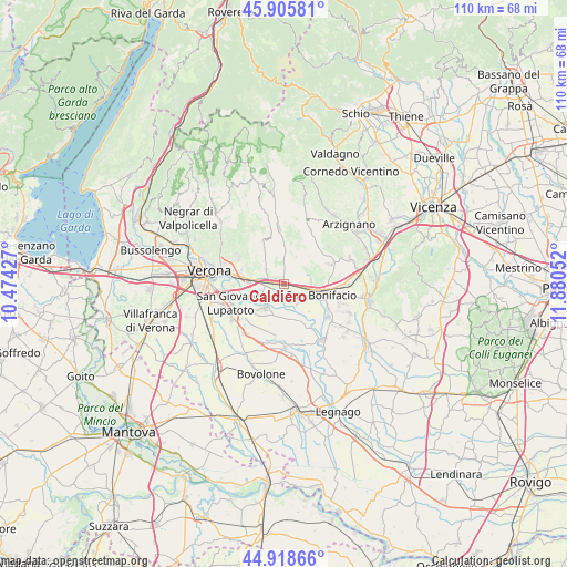
Caldiero GPS coordinates[2]
45° 24' 51.804" North, 11° 10' 38.604" East
| Map corner | latitude | longitude |
|---|---|---|
| Upper-left | 45.90581°, | 10.47427° |
| Center: | 45.41439°, | 11.17739° |
| Lower-right: | 44.91866°, | 11.88052° |
| Map W x H: | 109.8×109.8 km | = 68.2×68.2mi |
| max Lat: | 47.04031° ⇑29.3% North |
| Caldiero: | 45.41439° |
| min Lat: | ⇓70.7% South 35.50142° |
| min Long | Caldiero | max Long |
| 6.69888° | 11.17739° | 18.48682° |
| W 45.3%⇐ | ⇒54.7% E |
Elevation
Elevation of Caldiero is 46 m = 151 ft, and this is 260.7 m = 855 ft below average elevation for this country.
| Max E: |
2085 m = 6841 ft | 80.9% |
| Avg. | 306.7 m = 1006 ft | |
| Caldiero | 46 m = 151 ft | |
Min E: |
-4 m = -13 ft | 19.1% |
See also: Italy elevation on elevation.city.
Geographical zone
Caldiero is located in North temperate zone (between Tropic of Cancer and the Arctic Circle). Distance of this North polar circle is 2351.6 km =1461.2 mi to North.| Distance of | km | miles | from Caldiero |
|---|---|---|---|
| North Pole | 4957.5 | 3080.4 | to North |
| Arctic Circle | 2351.6 | 1461.2 | to North |
| Tropic Cancer | 2443.7 | 1518.4 | to South |
| Equator | 5049.6 | 3137.7 | to South |


Nearby cities:
15 places around Caldiero: (largest is in red/bold)
• Belfiore
4.5 km =2.8 mi,  144°
144°
• Caldierino-Rota
1.6 km =1 mi,  277°
277°
• Colognola ai Colli
2.2 km =1.4 mi,  14°
14°
• Illasi
5.8 km =3.6 mi,  3°
3°
• Lavagno
4.3 km =2.7 mi,  308°
308°
• Monticelli-Fontana
3.6 km =2.2 mi,  298°
298°
• Perzacco
5.7 km =3.5 mi,  173°
173°
• San Martino Buon Albergo
6.4 km =4 mi, 276°
• San Pietro
4.8 km =3 mi, 309°
• San Vittore
3.9 km =2.4 mi,  64°
64°
• Soave
5.4 km =3.4 mi,  83°
83°
• Strà-Montanara-Pieve
1.9 km =1.2 mi, 303°
• Vago
3.7 km =2.3 mi, 279°
• Villabella
5.5 km =3.4 mi,  103°
103°
• Zevio
6 km =3.7 mi,  218°
218°
Sources, notices
• [Note1] Compared only with cities in Italy existing in our database
• [Src1] Map data: © OpenStreetMap contributors (CC-BY-SA)
• [Src2] Other city data from geonames.org with taken over terms of usage.
• [Src3] Geographical zone / Annual Mean Temperature by Robert A. Rohde @ Wikipedia
