Balatro geodata
Balatro (Tuscany) is a populated place; located in Italy in Europe/Rome (GMT+2) time zone. With population of 705 people, there are 8268 cities with bigger population in this country. Compared to other cities in Italy, 57.9% of cities are located further ↑North; 52.9% of cities are located further →East and 59.4% of cities have higher elevation than Balatro. Note1


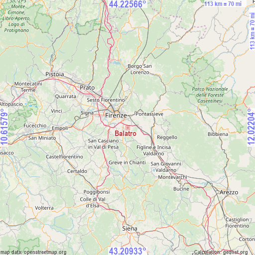
Balatro GPS coordinates[2]
43° 43' 10.74" North, 11° 19' 8.076" East
| Map corner | latitude | longitude |
|---|---|---|
| Upper-left | 44.22566°, | 10.61579° |
| Center: | 43.71965°, | 11.31891° |
| Lower-right: | 43.20933°, | 12.02204° |
| Map W x H: | 113×113 km | = 70.2×70.2mi |
| max Lat: | 47.04031° ⇑57.9% North |
| Balatro: | 43.71965° |
| min Lat: | ⇓42.1% South 35.50142° |
| min Long | Balatro | max Long |
| 6.69888° | 11.31891° | 18.48682° |
| W 47.1%⇐ | ⇒52.9% E |
Elevation
Elevation of Balatro is 168 m = 551 ft, and this is 138.7 m = 455 ft below average elevation for this country.
| Max E: |
2085 m = 6841 ft | 59.4% |
| Avg. | 306.7 m = 1006 ft | |
| Balatro | 168 m = 551 ft | |
Min E: |
-4 m = -13 ft | 40.6% |
See also: Italy elevation on elevation.city.
Geographical zone
Balatro is located in North temperate zone (between Tropic of Cancer and the Arctic Circle). Distance of this Northern Tropic circle is 2255.3 km =1401.4 mi to South.| Distance of | km | miles | from Balatro |
|---|---|---|---|
| North Pole | 5145.9 | 3197.5 | to North |
| Arctic Circle | 2540 | 1578.3 | to North |
| Tropic Cancer | 2255.3 | 1401.4 | to South |
| Equator | 4861.2 | 3020.6 | to South |


Nearby cities:
15 places around Balatro: (largest is in red/bold)
• Antella
0.9 km =0.6 mi,  16°
16°
• Bagno a Ripoli
3.5 km =2.2 mi,  4°
4°
• Chiocchio
9.2 km =5.7 mi,  181°
181°
• Compiobbi
7.9 km =4.9 mi, 23°
• Fiesole
9.6 km =6 mi,  348°
348°
• Florence
8.8 km =5.5 mi,  318°
318°
• Grassina Ponte a Ema
2.1 km =1.3 mi, 315°
• Impruneta
6.5 km =4 mi,  233°
233°
• Osteria Nuova
2.4 km =1.5 mi,  59°
59°
• Rimaggio
4.3 km =2.7 mi,  13°
13°
• San Jacopo al Girone
5.8 km =3.6 mi, 17°
• San Polo in Chianti
6.2 km =3.9 mi,  148°
148°
• Strada in Chianti
7 km =4.3 mi,  194°
194°
• Tavarnuzze
8.2 km =5.1 mi,  262°
262°
• Troghi
6.2 km =3.9 mi,  95°
95°
Sources, notices
• [Note1] Compared only with cities in Italy existing in our database
• [Src1] Map data: © OpenStreetMap contributors (CC-BY-SA)
• [Src2] Other city data from geonames.org with taken over terms of usage.
• [Src3] Geographical zone / Annual Mean Temperature by Robert A. Rohde @ Wikipedia
