Calvenzano geodata
Calvenzano (Lombardy) is a populated place; located in Italy in Europe/Rome (GMT+2) time zone. With population of 668 people, there are 8500 cities with bigger population in this country. Compared to other cities in Italy, 66.7% of cities are located further ↓South; 74.9% of cities are located further →East and 74.3% of cities have higher elevation than Calvenzano. Note1


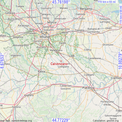
Calvenzano GPS coordinates[2]
45° 16' 9.444" North, 9° 22' 46.776" East
| Map corner | latitude | longitude |
|---|---|---|
| Upper-left | 45.76198°, | 8.67653° |
| Center: | 45.26929°, | 9.37966° |
| Lower-right: | 44.77229°, | 10.08279° |
| Map W x H: | 110×110 km | = 68.4×68.4mi |
| max Lat: | 47.04031° ⇑33.3% North |
| Calvenzano: | 45.26929° |
| min Lat: | ⇓66.7% South 35.50142° |
| min Long | Calvenzano | max Long |
| 6.69888° | 9.37966° | 18.48682° |
| W 25.1%⇐ | ⇒74.9% E |
Elevation
Elevation of Calvenzano is 77 m = 253 ft, and this is 229.7 m = 754 ft below average elevation for this country.
| Max E: |
2085 m = 6841 ft | 74.3% |
| Avg. | 306.7 m = 1006 ft | |
| Calvenzano | 77 m = 253 ft | |
Min E: |
-4 m = -13 ft | 25.7% |
See also: Italy elevation on elevation.city.
Geographical zone
Calvenzano is located in North temperate zone (between Tropic of Cancer and the Arctic Circle). Distance of this North polar circle is 2367.7 km =1471.2 mi to North.| Distance of | km | miles | from Calvenzano |
|---|---|---|---|
| North Pole | 4973.6 | 3090.5 | to North |
| Arctic Circle | 2367.7 | 1471.2 | to North |
| Tropic Cancer | 2427.6 | 1508.4 | to South |
| Equator | 5033.5 | 3127.7 | to South |


Nearby cities:
15 places around Calvenzano: (largest is in red/bold)
• Borgo San Giovanni
4.4 km =2.7 mi,  77°
77°
• Casaletto Lodigiano
3 km =1.9 mi,  332°
332°
• Caselle Lurani
2 km =1.2 mi,  309°
309°
• Castiraga Vidardo
2.4 km =1.5 mi,  124°
124°
• Lodi Vecchio
4.9 km =3 mi,  37°
37°
• Mairano
4.8 km =3 mi,  340°
340°
• Marudo
1.8 km =1.1 mi,  186°
186°
• Pieve Fissiraga
6.2 km =3.9 mi,  96°
96°
• Salerano sul Lambro
3.1 km =1.9 mi,  8°
8°
• Sant'Angelo Lodigiano
4.3 km =2.7 mi,  150°
150°
• Torre d'Arese
5.7 km =3.5 mi,  238°
238°
• Valera Fratta
3.7 km =2.3 mi,  248°
248°
• Vidardo
2.3 km =1.4 mi,  128°
128°
• Vigonzone
5.5 km =3.4 mi,  274°
274°
• Villanterio
5.9 km =3.7 mi, 194°
Sources, notices
• [Note1] Compared only with cities in Italy existing in our database
• [Src1] Map data: © OpenStreetMap contributors (CC-BY-SA)
• [Src2] Other city data from geonames.org with taken over terms of usage.
• [Src3] Geographical zone / Annual Mean Temperature by Robert A. Rohde @ Wikipedia
