Villanterio geodata
Villanterio (Lombardy) is a seat of a third-order administrative division; located in Italy in Europe/Rome (GMT+2) time zone. With population of 2,932 people, there are 3097 cities with bigger population in this country. Compared to other cities in Italy, 65.4% of cities are located further ↓South; 75.3% of cities are located further →East and 75.9% of cities have higher elevation than Villanterio. Note1


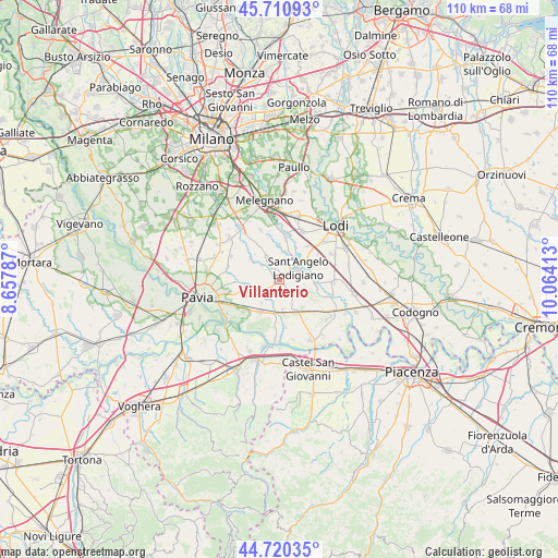
Villanterio GPS coordinates[2]
45° 13' 4.08" North, 9° 21' 39.6" East
| Map corner | latitude | longitude |
|---|---|---|
| Upper-left | 45.71093°, | 8.65787° |
| Center: | 45.2178°, | 9.361° |
| Lower-right: | 44.72035°, | 10.06413° |
| Map W x H: | 110.1×110.1 km | = 68.4×68.4mi |
| max Lat: | 47.04031° ⇑34.6% North |
| Villanterio: | 45.2178° |
| min Lat: | ⇓65.4% South 35.50142° |
| min Long | Villanterio | max Long |
| 6.69888° | 9.361° | 18.48682° |
| W 24.7%⇐ | ⇒75.3% E |
Elevation
Elevation of Villanterio is 70 m = 230 ft, and this is 236.7 m = 777 ft below average elevation for this country.
| Max E: |
2085 m = 6841 ft | 75.9% |
| Avg. | 306.7 m = 1006 ft | |
| Villanterio | 70 m = 230 ft | |
Min E: |
-4 m = -13 ft | 24.1% |
See also: Italy elevation on elevation.city.
Geographical zone
Villanterio is located in North temperate zone (between Tropic of Cancer and the Arctic Circle). Distance of this North polar circle is 2373.4 km =1474.8 mi to North.| Distance of | km | miles | from Villanterio |
|---|---|---|---|
| North Pole | 4979.3 | 3094 | to North |
| Arctic Circle | 2373.4 | 1474.8 | to North |
| Tropic Cancer | 2421.8 | 1504.8 | to South |
| Equator | 5027.7 | 3124.1 | to South |


Nearby cities:
15 places around Villanterio: (largest is in red/bold)
• Calvenzano
5.9 km =3.7 mi,  14°
14°
• Castiraga Vidardo
5.6 km =3.5 mi,  37°
37°
• Copiano
3.6 km =2.2 mi,  231°
231°
• Genzone
4.4 km =2.7 mi,  193°
193°
• Gerenzago
1.3 km =0.8 mi,  178°
178°
• Inverno
2.8 km =1.7 mi,  139°
139°
• Inverno e Monteleone
2.9 km =1.8 mi, 139°
• Magherno
2.6 km =1.6 mi,  284°
284°
• Marudo
4.1 km =2.5 mi,  17°
17°
• Monteleone
4.6 km =2.9 mi,  125°
125°
• Sant'Angelo Lodigiano
4.1 km =2.5 mi,  61°
61°
• Torre d'Arese
4.4 km =2.7 mi,  309°
309°
• Valera Fratta
4.8 km =3 mi,  336°
336°
• Vidardo
5.4 km =3.4 mi, 36°
• Vistarino
4.2 km =2.6 mi,  259°
259°
Sources, notices
• [Note1] Compared only with cities in Italy existing in our database
• [Src1] Map data: © OpenStreetMap contributors (CC-BY-SA)
• [Src2] Other city data from geonames.org with taken over terms of usage.
• [Src3] Geographical zone / Annual Mean Temperature by Robert A. Rohde @ Wikipedia
