Colorno geodata
Colorno (Emilia-Romagna) is a seat of a third-order administrative division; located in Italy in Europe/Rome (GMT+2) time zone. With population of 7,106 people, there are 1375 cities with bigger population in this country. Compared to other cities in Italy, 58.4% of cities are located further ↓South; 64.2% of cities are located further →East and 85.2% of cities have higher elevation than Colorno. Note1


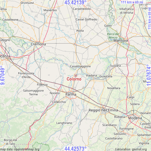
Colorno GPS coordinates[2]
44° 55' 32.592" North, 10° 22' 24.996" East
| Map corner | latitude | longitude |
|---|---|---|
| Upper-left | 45.42139°, | 9.67049° |
| Center: | 44.92572°, | 10.37361° |
| Lower-right: | 44.42573°, | 11.07674° |
| Map W x H: | 110.7×110.7 km | = 68.8×68.8mi |
| max Lat: | 47.04031° ⇑41.6% North |
| Colorno: | 44.92572° |
| min Lat: | ⇓58.4% South 35.50142° |
| min Long | Colorno | max Long |
| 6.69888° | 10.37361° | 18.48682° |
| W 35.8%⇐ | ⇒64.2% E |
Elevation
Elevation of Colorno is 30 m = 98 ft, and this is 276.7 m = 908 ft below average elevation for this country.
| Max E: |
2085 m = 6841 ft | 85.2% |
| Avg. | 306.7 m = 1006 ft | |
| Colorno | 30 m = 98 ft | |
Min E: |
-4 m = -13 ft | 14.8% |
See also: Italy elevation on elevation.city.
Geographical zone
Colorno is located in North temperate zone (between Tropic of Cancer and the Arctic Circle). Distance of this Northern Tropic circle is 2389.4 km =1484.7 mi to South.| Distance of | km | miles | from Colorno |
|---|---|---|---|
| North Pole | 5011.8 | 3114.2 | to North |
| Arctic Circle | 2405.9 | 1495 | to North |
| Tropic Cancer | 2389.4 | 1484.7 | to South |
| Equator | 4995.3 | 3103.9 | to South |


Nearby cities:
15 places around Colorno: (largest is in red/bold)
• Casalbellotto
9.1 km =5.7 mi,  63°
63°
• Casale
4.7 km =2.9 mi,  102°
102°
• Casale di Mezzani
4.6 km =2.9 mi, 104°
• Casalmaggiore
8 km =5 mi,  27°
27°
• Cervara
8.6 km =5.3 mi,  218°
218°
• Coltaro
6.1 km =3.8 mi,  317°
317°
• Mezzano Inferiore
6.8 km =4.2 mi, 102°
• Mezzano Superiore
4.1 km =2.5 mi,  79°
79°
• Rivarolo
5.1 km =3.2 mi,  242°
242°
• Roncadello
8.1 km =5 mi,  72°
72°
• Ronco Campo Canneto
9.3 km =5.8 mi,  255°
255°
• San Polo
4.2 km =2.6 mi,  198°
198°
• Torrile
3.9 km =2.4 mi,  269°
269°
• Trecasali
8 km =5 mi,  279°
279°
• Vicomoscano
8.1 km =5 mi,  47°
47°
Sources, notices
• [Note1] Compared only with cities in Italy existing in our database
• [Src1] Map data: © OpenStreetMap contributors (CC-BY-SA)
• [Src2] Other city data from geonames.org with taken over terms of usage.
• [Src3] Geographical zone / Annual Mean Temperature by Robert A. Rohde @ Wikipedia
