Abbadia geodata
Abbadia (The Marches) is a populated place; located in Italy in Europe/Rome (GMT+2) time zone. With population of 605 people, there are 8954 cities with bigger population in this country. Compared to other cities in Italy, 59.9% of cities are located further ↑North; 74% of cities are located further ←West and 66.5% of cities have higher elevation than Abbadia. Note1


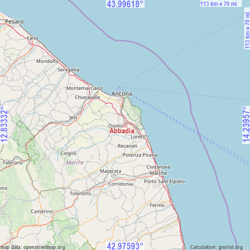
Abbadia GPS coordinates[2]
43° 29' 17.556" North, 13° 32' 11.184" East
| Map corner | latitude | longitude |
|---|---|---|
| Upper-left | 43.99618°, | 12.83332° |
| Center: | 43.48821°, | 13.53644° |
| Lower-right: | 42.97593°, | 14.23957° |
| Map W x H: | 113.4×113.4 km | = 70.5×70.5mi |
| max Lat: | 47.04031° ⇑59.9% North |
| Abbadia: | 43.48821° |
| min Lat: | ⇓40.1% South 35.50142° |
| min Long | Abbadia | max Long |
| 6.69888° | 13.53644° | 18.48682° |
| W 74%⇐ | ⇒26% E |
Elevation
Elevation of Abbadia is 118 m = 387 ft, and this is 188.7 m = 619 ft below average elevation for this country.
| Max E: |
2085 m = 6841 ft | 66.5% |
| Avg. | 306.7 m = 1006 ft | |
| Abbadia | 118 m = 387 ft | |
Min E: |
-4 m = -13 ft | 33.5% |
See also: Italy elevation on elevation.city.
Geographical zone
Abbadia is located in North temperate zone (between Tropic of Cancer and the Arctic Circle). Distance of this Northern Tropic circle is 2229.5 km =1385.3 mi to South.| Distance of | km | miles | from Abbadia |
|---|---|---|---|
| North Pole | 5171.6 | 3213.5 | to North |
| Arctic Circle | 2565.7 | 1594.3 | to North |
| Tropic Cancer | 2229.5 | 1385.3 | to South |
| Equator | 4835.4 | 3004.6 | to South |


Nearby cities:
15 places around Abbadia: (largest is in red/bold)
• Aspio
5.9 km =3.7 mi,  330°
330°
• Camerano
4.6 km =2.9 mi,  16°
16°
• Campocavallo
4.4 km =2.7 mi,  226°
226°
• Castelfidardo
3.4 km =2.1 mi,  160°
160°
• Marcelli
7.2 km =4.5 mi,  86°
86°
• Musone
6.6 km =4.1 mi,  137°
137°
• Numana
7.3 km =4.5 mi,  69°
69°
• Osimo
4.4 km =2.7 mi,  265°
265°
• Padiglione
6.3 km =3.9 mi,  250°
250°
• Ponte dell'Aspio
5.5 km =3.4 mi, 326°
• San Biagio
4.5 km =2.8 mi,  313°
313°
• San Rocchetto
2.7 km =1.7 mi,  96°
96°
• San Sabino
2.6 km =1.6 mi, 231°
• Villa Musone
7.1 km =4.4 mi,  130°
130°
• Villaggio Taunus
6.2 km =3.9 mi,  76°
76°
Sources, notices
• [Note1] Compared only with cities in Italy existing in our database
• [Src1] Map data: © OpenStreetMap contributors (CC-BY-SA)
• [Src2] Other city data from geonames.org with taken over terms of usage.
• [Src3] Geographical zone / Annual Mean Temperature by Robert A. Rohde @ Wikipedia
