Numana geodata
Numana (The Marches) is a seat of a third-order administrative division; located in Italy in Europe/Rome (GMT+2) time zone. With population of 1,322 people, there are 5561 cities with bigger population in this country. Compared to other cities in Italy, 59.7% of cities are located further ↑North; 74.8% of cities are located further ←West and 86.7% of cities have higher elevation than Numana. Note1


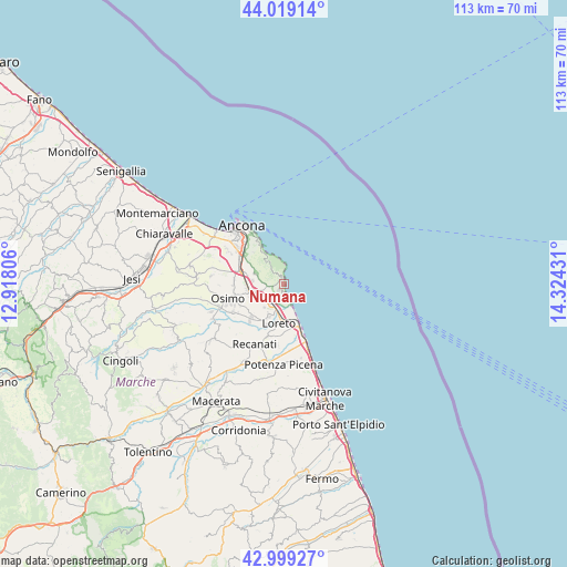
Numana GPS coordinates[2]
43° 30' 40.896" North, 13° 37' 16.248" East
| Map corner | latitude | longitude |
|---|---|---|
| Upper-left | 44.01914°, | 12.91806° |
| Center: | 43.51136°, | 13.62118° |
| Lower-right: | 42.99927°, | 14.32431° |
| Map W x H: | 113.4×113.4 km | = 70.5×70.5mi |
| max Lat: | 47.04031° ⇑59.7% North |
| Numana: | 43.51136° |
| min Lat: | ⇓40.3% South 35.50142° |
| min Long | Numana | max Long |
| 6.69888° | 13.62118° | 18.48682° |
| W 74.8%⇐ | ⇒25.2% E |
Elevation
Elevation of Numana is 26 m = 85 ft, and this is 280.7 m = 921 ft below average elevation for this country.
| Max E: |
2085 m = 6841 ft | 86.7% |
| Avg. | 306.7 m = 1006 ft | |
| Numana | 26 m = 85 ft | |
Min E: |
-4 m = -13 ft | 13.3% |
See also: Italy elevation on elevation.city.
Geographical zone
Numana is located in North temperate zone (between Tropic of Cancer and the Arctic Circle). Distance of this Northern Tropic circle is 2232.1 km =1387 mi to South.| Distance of | km | miles | from Numana |
|---|---|---|---|
| North Pole | 5169.1 | 3211.9 | to North |
| Arctic Circle | 2563.2 | 1592.7 | to North |
| Tropic Cancer | 2232.1 | 1387 | to South |
| Equator | 4838 | 3006.2 | to South |


Nearby cities:
15 places around Numana: (largest is in red/bold)
• Abbadia
7.3 km =4.5 mi,  249°
249°
• Camerano
5.8 km =3.6 mi,  288°
288°
• Castelfidardo
8.1 km =5 mi,  224°
224°
• Loreto
8.4 km =5.2 mi,  184°
184°
• Loreto Stazione
7.1 km =4.4 mi, 180°
• Marcelli
2.2 km =1.4 mi,  170°
170°
• Musone
7.8 km =4.8 mi,  197°
197°
• Ponte dell'Aspio
10 km =6.2 mi,  281°
281°
• Porto Recanati
9.3 km =5.8 mi,  159°
159°
• San Rocchetto
5.1 km =3.2 mi,  235°
235°
• San Sabino
9.8 km =6.1 mi, 244°
• Sirolo
1.3 km =0.8 mi,  337°
337°
• Varano
8.9 km =5.5 mi,  317°
317°
• Villa Musone
7.4 km =4.6 mi,  191°
191°
• Villaggio Taunus
1.4 km =0.9 mi, 217°
Sources, notices
• [Note1] Compared only with cities in Italy existing in our database
• [Src1] Map data: © OpenStreetMap contributors (CC-BY-SA)
• [Src2] Other city data from geonames.org with taken over terms of usage.
• [Src3] Geographical zone / Annual Mean Temperature by Robert A. Rohde @ Wikipedia
