Padiglione geodata
Padiglione (The Marches) is a populated place; located in Italy in Europe/Rome (GMT+2) time zone. With population of 1,106 people, there are 6271 cities with bigger population in this country. Compared to other cities in Italy, 60.2% of cities are located further ↑North; 73.1% of cities are located further ←West and 78.1% of cities have higher elevation than Padiglione. Note1


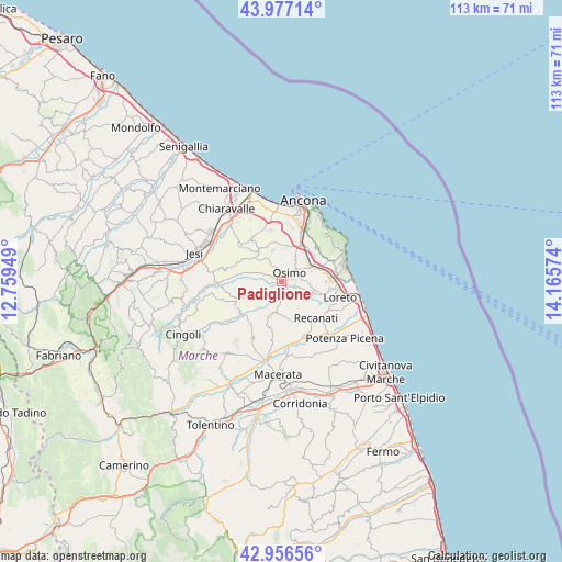
Padiglione GPS coordinates[2]
43° 28' 8.4" North, 13° 27' 45.396" East
| Map corner | latitude | longitude |
|---|---|---|
| Upper-left | 43.97714°, | 12.75949° |
| Center: | 43.469°, | 13.46261° |
| Lower-right: | 42.95656°, | 14.16574° |
| Map W x H: | 113.5×113.5 km | = 70.5×70.5mi |
| max Lat: | 47.04031° ⇑60.2% North |
| Padiglione: | 43.469° |
| min Lat: | ⇓39.8% South 35.50142° |
| min Long | Padiglione | max Long |
| 6.69888° | 13.46261° | 18.48682° |
| W 73.1%⇐ | ⇒26.9% E |
Elevation
Elevation of Padiglione is 59 m = 194 ft, and this is 247.7 m = 813 ft below average elevation for this country.
| Max E: |
2085 m = 6841 ft | 78.1% |
| Avg. | 306.7 m = 1006 ft | |
| Padiglione | 59 m = 194 ft | |
Min E: |
-4 m = -13 ft | 21.9% |
See also: Italy elevation on elevation.city.
Geographical zone
Padiglione is located in North temperate zone (between Tropic of Cancer and the Arctic Circle). Distance of this Northern Tropic circle is 2227.4 km =1384 mi to South.| Distance of | km | miles | from Padiglione |
|---|---|---|---|
| North Pole | 5173.8 | 3214.8 | to North |
| Arctic Circle | 2567.9 | 1595.6 | to North |
| Tropic Cancer | 2227.4 | 1384 | to South |
| Equator | 4833.3 | 3003.3 | to South |


Nearby cities:
15 places around Padiglione: (largest is in red/bold)
• Abbadia
6.3 km =3.9 mi,  70°
70°
• Aspio
7.8 km =4.8 mi,  22°
22°
• Camerano
9.8 km =6.1 mi,  48°
48°
• Campocavallo
2.9 km =1.8 mi,  107°
107°
• Castelfidardo
7.2 km =4.5 mi,  98°
98°
• Filottrano
9.7 km =6 mi,  247°
247°
• Montefano
6.9 km =4.3 mi,  197°
197°
• Montoro
4.2 km =2.6 mi, 248°
• Offagna
6.6 km =4.1 mi,  344°
344°
• Osimo
2.4 km =1.5 mi,  40°
40°
• Polverigi
9.2 km =5.7 mi,  315°
315°
• Ponte dell'Aspio
7.3 km =4.5 mi, 23°
• San Biagio
5.9 km =3.7 mi,  27°
27°
• San Rocchetto
8.8 km =5.5 mi,  78°
78°
• San Sabino
4 km =2.5 mi, 82°
Sources, notices
• [Note1] Compared only with cities in Italy existing in our database
• [Src1] Map data: © OpenStreetMap contributors (CC-BY-SA)
• [Src2] Other city data from geonames.org with taken over terms of usage.
• [Src3] Geographical zone / Annual Mean Temperature by Robert A. Rohde @ Wikipedia
