Grossa geodata
Grossa (Veneto) is a populated place; located in Italy in Europe/Rome (GMT+2) time zone. With population of 601 people, there are 8996 cities with bigger population in this country. Compared to other cities in Italy, 75.5% of cities are located further ↓South; 51.8% of cities are located further ←West and 85.6% of cities have higher elevation than Grossa. Note1


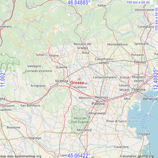
Grossa GPS coordinates[2]
45° 33' 31.284" North, 11° 42' 18.432" East
| Map corner | latitude | longitude |
|---|---|---|
| Upper-left | 46.04885°, | 11.002° |
| Center: | 45.55869°, | 11.70512° |
| Lower-right: | 45.06422°, | 12.40825° |
| Map W x H: | 109.5×109.5 km | = 68×68mi |
| max Lat: | 47.04031° ⇑24.5% North |
| Grossa: | 45.55869° |
| min Lat: | ⇓75.5% South 35.50142° |
| min Long | Grossa | max Long |
| 6.69888° | 11.70512° | 18.48682° |
| W 51.8%⇐ | ⇒48.2% E |
Elevation
Elevation of Grossa is 29 m = 95 ft, and this is 277.7 m = 911 ft below average elevation for this country.
| Max E: |
2085 m = 6841 ft | 85.6% |
| Avg. | 306.7 m = 1006 ft | |
| Grossa | 29 m = 95 ft | |
Min E: |
-4 m = -13 ft | 14.4% |
See also: Italy elevation on elevation.city.
Geographical zone
Grossa is located in North temperate zone (between Tropic of Cancer and the Arctic Circle). Distance of this North polar circle is 2335.5 km =1451.2 mi to North.| Distance of | km | miles | from Grossa |
|---|---|---|---|
| North Pole | 4941.4 | 3070.4 | to North |
| Arctic Circle | 2335.5 | 1451.2 | to North |
| Tropic Cancer | 2459.7 | 1528.4 | to South |
| Equator | 5065.7 | 3147.7 | to South |


Nearby cities:
15 places around Grossa: (largest is in red/bold)
• Bevadoro
5.9 km =3.7 mi,  153°
153°
• Camisano Vicentino
4.1 km =2.5 mi,  176°
176°
• Gazzo
2.6 km =1.6 mi,  3°
3°
• Grantorto
5.3 km =3.3 mi,  22°
22°
• Grumolo delle Abbadesse
5.3 km =3.3 mi,  209°
209°
• Lanzè
4.6 km =2.9 mi,  311°
311°
• Marola
6.5 km =4 mi,  251°
251°
• Piazzola sul Brenta
6.6 km =4.1 mi,  110°
110°
• Presina
3.7 km =2.3 mi,  86°
86°
• Quinto Vicentino
6.3 km =3.9 mi,  287°
287°
• Rampazzo
2.8 km =1.7 mi,  215°
215°
• San Pietro in Gu
6.1 km =3.8 mi,  336°
336°
• Sarmego
6.9 km =4.3 mi,  200°
200°
• Valproto
4.6 km =2.9 mi,  269°
269°
• Villalta
2.8 km =1.7 mi,  317°
317°
Sources, notices
• [Note1] Compared only with cities in Italy existing in our database
• [Src1] Map data: © OpenStreetMap contributors (CC-BY-SA)
• [Src2] Other city data from geonames.org with taken over terms of usage.
• [Src3] Geographical zone / Annual Mean Temperature by Robert A. Rohde @ Wikipedia
