Lova geodata
Lova (Veneto) is a populated place; located in Italy in Europe/Rome (GMT+2) time zone. With population of 600 people, there are 9006 cities with bigger population in this country. Compared to other cities in Italy, 68.2% of cities are located further ↓South; 57.7% of cities are located further ←West and 100% of cities have higher elevation than Lova. Note1


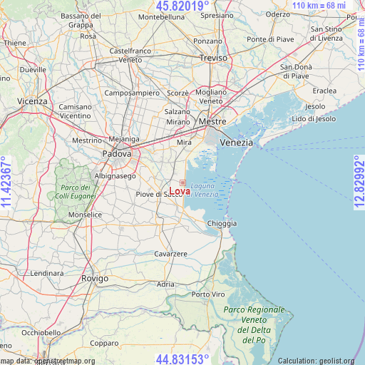
Lova GPS coordinates[2]
45° 19' 40.872" North, 12° 7' 36.444" East
| Map corner | latitude | longitude |
|---|---|---|
| Upper-left | 45.82019°, | 11.42367° |
| Center: | 45.32802°, | 12.12679° |
| Lower-right: | 44.83153°, | 12.82992° |
| Map W x H: | 109.9×109.9 km | = 68.3×68.3mi |
| max Lat: | 47.04031° ⇑31.8% North |
| Lova: | 45.32802° |
| min Lat: | ⇓68.2% South 35.50142° |
| min Long | Lova | max Long |
| 6.69888° | 12.12679° | 18.48682° |
| W 57.7%⇐ | ⇒42.3% E |
Elevation
Elevation of Lova is -2 m = -7 ft, and this is 308.7 m = 1013 ft below average elevation for this country.
| Max E: |
2085 m = 6841 ft | 100% |
| Avg. | 306.7 m = 1006 ft | |
| Lova | -2 m = -7 ft | |
Min E: |
-4 m = -13 ft | 0% |
See also: Italy elevation on elevation.city.
Geographical zone
Lova is located in North temperate zone (between Tropic of Cancer and the Arctic Circle). Distance of this North polar circle is 2361.2 km =1467.2 mi to North.| Distance of | km | miles | from Lova |
|---|---|---|---|
| North Pole | 4967.1 | 3086.4 | to North |
| Arctic Circle | 2361.2 | 1467.2 | to North |
| Tropic Cancer | 2434.1 | 1512.5 | to South |
| Equator | 5040 | 3131.7 | to South |


Nearby cities:
15 places around Lova: (largest is in red/bold)
• Arzergrande
8.7 km =5.4 mi,  224°
224°
• Bojon-Lova
3.7 km =2.3 mi,  290°
290°
• Cambroso
5.7 km =3.5 mi, 216°
• Campagna Lupia
3.7 km =2.3 mi,  321°
321°
• Campolongo Maggiore
6.5 km =4 mi,  265°
265°
• Campolongo Maggiore Liettoli
8.1 km =5 mi,  278°
278°
• Camponogara
6.5 km =4 mi,  331°
331°
• Codevigo
7.2 km =4.5 mi,  197°
197°
• Corte
4.8 km =3 mi,  243°
243°
• Fossò
9 km =5.6 mi, 315°
• Lughetto
6.5 km =4 mi,  2°
2°
• Piove di Sacco-Piovega
7.9 km =4.9 mi, 243°
• Sandon
7.7 km =4.8 mi,  301°
301°
• Sant'Angelo di Piove di Sacco
9.3 km =5.8 mi,  262°
262°
• Vallonga
7.2 km =4.5 mi,  211°
211°
Sources, notices
• [Note1] Compared only with cities in Italy existing in our database
• [Src1] Map data: © OpenStreetMap contributors (CC-BY-SA)
• [Src2] Other city data from geonames.org with taken over terms of usage.
• [Src3] Geographical zone / Annual Mean Temperature by Robert A. Rohde @ Wikipedia
