Bagnolo geodata
Bagnolo (Veneto) is a populated place; located in Italy in Europe/Rome (GMT+2) time zone. With population of 597 people, there are 9041 cities with bigger population in this country. Compared to other cities in Italy, 69% of cities are located further ↓South; 52.2% of cities are located further →East and 87% of cities have higher elevation than Bagnolo. Note1


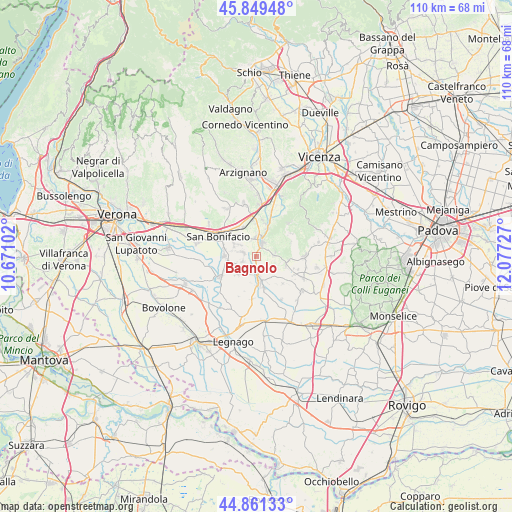
Bagnolo GPS coordinates[2]
45° 21' 27.216" North, 11° 22' 26.904" East
| Map corner | latitude | longitude |
|---|---|---|
| Upper-left | 45.84948°, | 10.67102° |
| Center: | 45.35756°, | 11.37414° |
| Lower-right: | 44.86133°, | 12.07727° |
| Map W x H: | 109.9×109.9 km | = 68.3×68.3mi |
| max Lat: | 47.04031° ⇑31% North |
| Bagnolo: | 45.35756° |
| min Lat: | ⇓69% South 35.50142° |
| min Long | Bagnolo | max Long |
| 6.69888° | 11.37414° | 18.48682° |
| W 47.8%⇐ | ⇒52.2% E |
Elevation
Elevation of Bagnolo is 25 m = 82 ft, and this is 281.7 m = 924 ft below average elevation for this country.
| Max E: |
2085 m = 6841 ft | 87% |
| Avg. | 306.7 m = 1006 ft | |
| Bagnolo | 25 m = 82 ft | |
Min E: |
-4 m = -13 ft | 13% |
See also: Italy elevation on elevation.city.
Geographical zone
Bagnolo is located in North temperate zone (between Tropic of Cancer and the Arctic Circle). Distance of this North polar circle is 2357.9 km =1465.1 mi to North.| Distance of | km | miles | from Bagnolo |
|---|---|---|---|
| North Pole | 4963.8 | 3084.4 | to North |
| Arctic Circle | 2357.9 | 1465.1 | to North |
| Tropic Cancer | 2437.4 | 1514.5 | to South |
| Equator | 5043.3 | 3133.8 | to South |


Nearby cities:
15 places around Bagnolo: (largest is in red/bold)
• Albaredo d'Adige
8.6 km =5.3 mi,  239°
239°
• Alonte
4.2 km =2.6 mi,  77°
77°
• Arcole
6.8 km =4.2 mi,  273°
273°
• Asigliano Veneto
8.2 km =5.1 mi,  136°
136°
• Cologna Veneta
5.6 km =3.5 mi,  175°
175°
• Gazzolo-Volpino
5.2 km =3.2 mi,  292°
292°
• Locara
6.9 km =4.3 mi,  331°
331°
• Lonigo
3.2 km =2 mi,  13°
13°
• Monticello di Fara
8 km =5 mi, 9°
• Orgiano
7.2 km =4.5 mi,  111°
111°
• San Gregorio
6.1 km =3.8 mi,  254°
254°
• Santo Stefano-Bonaldo
3.5 km =2.2 mi, 287°
• Sarego
6 km =3.7 mi,  21°
21°
• Veronella
5.3 km =3.3 mi,  225°
225°
• Zimella
2.9 km =1.8 mi, 176°
Sources, notices
• [Note1] Compared only with cities in Italy existing in our database
• [Src1] Map data: © OpenStreetMap contributors (CC-BY-SA)
• [Src2] Other city data from geonames.org with taken over terms of usage.
• [Src3] Geographical zone / Annual Mean Temperature by Robert A. Rohde @ Wikipedia
