Pezzalunga geodata
Pezzalunga (Campania) is a populated place; located in Italy in Europe/Rome (GMT+2) time zone. With population of 585 people, there are 9134 cities with bigger population in this country. Compared to other cities in Italy, 78.8% of cities are located further ↑North; 82.1% of cities are located further ←West and 84.4% of cities have higher elevation than Pezzalunga. Note1


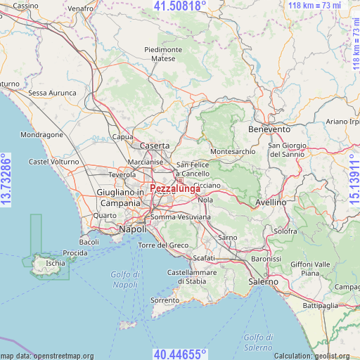
Pezzalunga GPS coordinates[2]
40° 58' 46.2" North, 14° 26' 9.528" East
| Map corner | latitude | longitude |
|---|---|---|
| Upper-left | 41.50818°, | 13.73286° |
| Center: | 40.9795°, | 14.43598° |
| Lower-right: | 40.44655°, | 15.13911° |
| Map W x H: | 118×118 km | = 73.3×73.3mi |
| max Lat: | 47.04031° ⇑78.8% North |
| Pezzalunga: | 40.9795° |
| min Lat: | ⇓21.2% South 35.50142° |
| min Long | Pezzalunga | max Long |
| 6.69888° | 14.43598° | 18.48682° |
| W 82.1%⇐ | ⇒17.9% E |
Elevation
Elevation of Pezzalunga is 33 m = 108 ft, and this is 273.7 m = 898 ft below average elevation for this country.
| Max E: |
2085 m = 6841 ft | 84.4% |
| Avg. | 306.7 m = 1006 ft | |
| Pezzalunga | 33 m = 108 ft | |
Min E: |
-4 m = -13 ft | 15.6% |
See also: Italy elevation on elevation.city.
Geographical zone
Pezzalunga is located in North temperate zone (between Tropic of Cancer and the Arctic Circle). Distance of this Northern Tropic circle is 1950.6 km =1212 mi to South.| Distance of | km | miles | from Pezzalunga |
|---|---|---|---|
| North Pole | 5450.6 | 3386.8 | to North |
| Arctic Circle | 2844.7 | 1767.6 | to North |
| Tropic Cancer | 1950.6 | 1212 | to South |
| Equator | 4556.5 | 2831.3 | to South |


Nearby cities:
15 places around Pezzalunga: (largest is in red/bold)
• Acerra
6.7 km =4.2 mi,  234°
234°
• Arienzo
7.4 km =4.6 mi,  44°
44°
• Brusciano
6.4 km =4 mi,  189°
189°
• Camposano
8.4 km =5.2 mi,  110°
110°
• Castello di Cisterna
7.4 km =4.6 mi,  196°
196°
• Cervino
6.8 km =4.2 mi,  351°
351°
• Cicciano
8.5 km =5.3 mi,  101°
101°
• Cimitile
8.6 km =5.3 mi,  118°
118°
• Maddaloni
7.7 km =4.8 mi,  324°
324°
• Mariglianella
5.5 km =3.4 mi,  179°
179°
• Marigliano
6.3 km =3.9 mi,  164°
164°
• Montedecoro
5.6 km =3.5 mi,  344°
344°
• San Felice A Cancello
6 km =3.7 mi,  45°
45°
• San Vitaliano
6.9 km =4.3 mi,  152°
152°
• Santa Maria A Vico
5.7 km =3.5 mi,  25°
25°
Sources, notices
• [Note1] Compared only with cities in Italy existing in our database
• [Src1] Map data: © OpenStreetMap contributors (CC-BY-SA)
• [Src2] Other city data from geonames.org with taken over terms of usage.
• [Src3] Geographical zone / Annual Mean Temperature by Robert A. Rohde @ Wikipedia
