Mariglianella geodata
Mariglianella (Campania) is a seat of a third-order administrative division; located in Italy in Europe/Rome (GMT+2) time zone. With population of 6,509 people, there are 1499 cities with bigger population in this country. Compared to other cities in Italy, 79.4% of cities are located further ↑North; 82.1% of cities are located further ←West and 86.7% of cities have higher elevation than Mariglianella. Note1


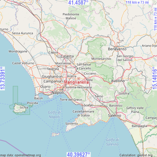
Mariglianella GPS coordinates[2]
40° 55' 46.632" North, 14° 26' 13.308" East
| Map corner | latitude | longitude |
|---|---|---|
| Upper-left | 41.4587°, | 13.73391° |
| Center: | 40.92962°, | 14.43703° |
| Lower-right: | 40.39627°, | 15.14016° |
| Map W x H: | 118.1×118.1 km | = 73.4×73.4mi |
| max Lat: | 47.04031° ⇑79.4% North |
| Mariglianella: | 40.92962° |
| min Lat: | ⇓20.6% South 35.50142° |
| min Long | Mariglianella | max Long |
| 6.69888° | 14.43703° | 18.48682° |
| W 82.1%⇐ | ⇒17.9% E |
Elevation
Elevation of Mariglianella is 26 m = 85 ft, and this is 280.7 m = 921 ft below average elevation for this country.
| Max E: |
2085 m = 6841 ft | 86.7% |
| Avg. | 306.7 m = 1006 ft | |
| Mariglianella | 26 m = 85 ft | |
Min E: |
-4 m = -13 ft | 13.3% |
See also: Italy elevation on elevation.city.
Geographical zone
Mariglianella is located in North temperate zone (between Tropic of Cancer and the Arctic Circle). Distance of this Northern Tropic circle is 1945 km =1208.6 mi to South.| Distance of | km | miles | from Mariglianella |
|---|---|---|---|
| North Pole | 5456.1 | 3390.3 | to North |
| Arctic Circle | 2850.2 | 1771 | to North |
| Tropic Cancer | 1945 | 1208.6 | to South |
| Equator | 4550.9 | 2827.8 | to South |


Nearby cities:
15 places around Mariglianella: (largest is in red/bold)
• Acerra
5.8 km =3.6 mi,  286°
286°
• Brusciano
1.4 km =0.9 mi,  233°
233°
• Capo Mazzo
7.3 km =4.5 mi,  265°
265°
• Castello di Cisterna
2.7 km =1.7 mi,  235°
235°
• Marigliano
1.7 km =1.1 mi,  108°
108°
• Pezzalunga
5.5 km =3.4 mi,  359°
359°
• Pomigliano d'Arco
5 km =3.1 mi, 243°
• Ponte di Ferro
6.1 km =3.8 mi,  216°
216°
• San Vitaliano
3.2 km =2 mi,  100°
100°
• Sant'Anastasia
7.4 km =4.6 mi,  203°
203°
• Saviano
6.3 km =3.9 mi,  115°
115°
• Scisciano
4.1 km =2.5 mi,  129°
129°
• Somma Vesuviana
6.3 km =3.9 mi,  178°
178°
• Spartimento
5.2 km =3.2 mi,  145°
145°
• Starza Vecchia
5.3 km =3.3 mi,  214°
214°
Sources, notices
• [Note1] Compared only with cities in Italy existing in our database
• [Src1] Map data: © OpenStreetMap contributors (CC-BY-SA)
• [Src2] Other city data from geonames.org with taken over terms of usage.
• [Src3] Geographical zone / Annual Mean Temperature by Robert A. Rohde @ Wikipedia
