Feglino geodata
Feglino (Liguria) is a seat of a third-order administrative division; located in Italy in Europe/Rome (GMT+2) time zone. With population of 582 people, there are 9160 cities with bigger population in this country. Compared to other cities in Italy, 52.6% of cities are located further ↑North; 89.9% of cities are located further →East and 62.8% of cities have higher elevation than Feglino. Note1


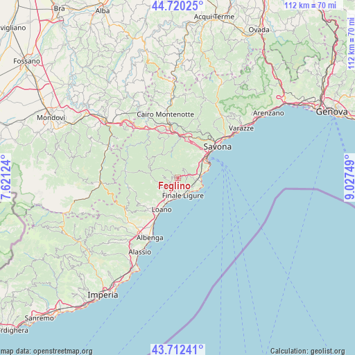
Feglino GPS coordinates[2]
44° 13' 6.564" North, 8° 19' 27.696" East
| Map corner | latitude | longitude |
|---|---|---|
| Upper-left | 44.72025°, | 7.62124° |
| Center: | 44.21849°, | 8.32436° |
| Lower-right: | 43.71241°, | 9.02749° |
| Map W x H: | 112.1×112.1 km | = 69.7×69.7mi |
| max Lat: | 47.04031° ⇑52.6% North |
| Feglino: | 44.21849° |
| min Lat: | ⇓47.4% South 35.50142° |
| min Long | Feglino | max Long |
| 6.69888° | 8.32436° | 18.48682° |
| W 10.1%⇐ | ⇒89.9% E |
Elevation
Elevation of Feglino is 143 m = 469 ft, and this is 163.7 m = 537 ft below average elevation for this country.
| Max E: |
2085 m = 6841 ft | 62.8% |
| Avg. | 306.7 m = 1006 ft | |
| Feglino | 143 m = 469 ft | |
Min E: |
-4 m = -13 ft | 37.2% |
See also: Italy elevation on elevation.city.
Geographical zone
Feglino is located in North temperate zone (between Tropic of Cancer and the Arctic Circle). Distance of this Northern Tropic circle is 2310.7 km =1435.8 mi to South.| Distance of | km | miles | from Feglino |
|---|---|---|---|
| North Pole | 5090.4 | 3163 | to North |
| Arctic Circle | 2484.5 | 1543.8 | to North |
| Tropic Cancer | 2310.7 | 1435.8 | to South |
| Equator | 4916.6 | 3055 | to South |


Nearby cities:
15 places around Feglino: (largest is in red/bold)
• Borgio
6.7 km =4.2 mi,  190°
190°
• Calice Ligure
2.8 km =1.7 mi,  236°
236°
• Finale Ligure
5.7 km =3.5 mi,  164°
164°
• Gorra
4.5 km =2.8 mi,  207°
207°
• Magliolo
6.6 km =4.1 mi, 244°
• Noli
7.3 km =4.5 mi,  100°
100°
• Orco Feglino
0.2 km =0.1 mi,  4°
4°
• Rialto
5.1 km =3.2 mi,  280°
280°
• San Lorenzo
8.1 km =5 mi,  231°
231°
• Sant'Ermete
7.3 km =4.5 mi,  55°
55°
• Spotorno
7.4 km =4.6 mi,  83°
83°
• Tovo San Giacomo
6.4 km =4 mi,  222°
222°
• Varigotti
7 km =4.3 mi,  125°
125°
• Vezzi Portio
3.5 km =2.2 mi,  69°
69°
• Voze
5.7 km =3.5 mi, 95°
Sources, notices
• [Note1] Compared only with cities in Italy existing in our database
• [Src1] Map data: © OpenStreetMap contributors (CC-BY-SA)
• [Src2] Other city data from geonames.org with taken over terms of usage.
• [Src3] Geographical zone / Annual Mean Temperature by Robert A. Rohde @ Wikipedia
