Gorra geodata
Gorra (Liguria) is a populated place; located in Italy in Europe/Rome (GMT+2) time zone. With population of 510 people, there are 9825 cities with bigger population in this country. Compared to other cities in Italy, 52.9% of cities are located further ↑North; 90.1% of cities are located further →East and 54.6% of cities have higher elevation than Gorra. Note1


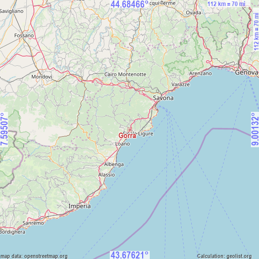
Gorra GPS coordinates[2]
44° 10' 57.324" North, 8° 17' 53.484" East
| Map corner | latitude | longitude |
|---|---|---|
| Upper-left | 44.68466°, | 7.59507° |
| Center: | 44.18259°, | 8.29819° |
| Lower-right: | 43.67621°, | 9.00132° |
| Map W x H: | 112.1×112.1 km | = 69.7×69.7mi |
| max Lat: | 47.04031° ⇑52.9% North |
| Gorra: | 44.18259° |
| min Lat: | ⇓47.1% South 35.50142° |
| min Long | Gorra | max Long |
| 6.69888° | 8.29819° | 18.48682° |
| W 9.9%⇐ | ⇒90.1% E |
Elevation
Elevation of Gorra is 205 m = 673 ft, and this is 101.7 m = 334 ft below average elevation for this country.
| Max E: |
2085 m = 6841 ft | 54.6% |
| Avg. | 306.7 m = 1006 ft | |
| Gorra | 205 m = 673 ft | |
Min E: |
-4 m = -13 ft | 45.4% |
See also: Italy elevation on elevation.city.
Geographical zone
Gorra is located in North temperate zone (between Tropic of Cancer and the Arctic Circle). Distance of this Northern Tropic circle is 2306.7 km =1433.3 mi to South.| Distance of | km | miles | from Gorra |
|---|---|---|---|
| North Pole | 5094.4 | 3165.5 | to North |
| Arctic Circle | 2488.5 | 1546.3 | to North |
| Tropic Cancer | 2306.7 | 1433.3 | to South |
| Equator | 4912.6 | 3052.5 | to South |


Nearby cities:
15 places around Gorra: (largest is in red/bold)
• Boissano
8 km =5 mi,  229°
229°
• Borgio
2.7 km =1.7 mi,  162°
162°
• Calice Ligure
2.5 km =1.6 mi,  354°
354°
• Feglino
4.5 km =2.8 mi,  27°
27°
• Finale Ligure
3.9 km =2.4 mi,  111°
111°
• Giustenice
4.5 km =2.8 mi,  256°
256°
• Loano
6.9 km =4.3 mi,  208°
208°
• Magliolo
4 km =2.5 mi,  285°
285°
• Orco Feglino
4.7 km =2.9 mi, 26°
• Pietra Ligure
3.9 km =2.4 mi,  199°
199°
• Rialto
5.7 km =3.5 mi,  328°
328°
• San Lorenzo
4.4 km =2.7 mi, 256°
• Tovo San Giacomo
2.3 km =1.4 mi,  251°
251°
• Varigotti
7.8 km =4.8 mi,  90°
90°
• Vezzi Portio
7.4 km =4.6 mi,  45°
45°
Sources, notices
• [Note1] Compared only with cities in Italy existing in our database
• [Src1] Map data: © OpenStreetMap contributors (CC-BY-SA)
• [Src2] Other city data from geonames.org with taken over terms of usage.
• [Src3] Geographical zone / Annual Mean Temperature by Robert A. Rohde @ Wikipedia
