Rialto geodata
Rialto (Liguria) is a seat of a third-order administrative division; located in Italy in Europe/Rome (GMT+2) time zone. With population of 66 people, there are 11548 cities with bigger population in this country. Compared to other cities in Italy, 52.5% of cities are located further ↑North; 90.5% of cities are located further →East and 66.9% of cities have lower elevation than Rialto. Note1


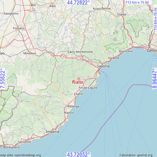
Rialto GPS coordinates[2]
44° 13' 35.508" North, 8° 15' 40.86" East
| Map corner | latitude | longitude |
|---|---|---|
| Upper-left | 44.72822°, | 7.55822° |
| Center: | 44.22653°, | 8.26135° |
| Lower-right: | 43.72052°, | 8.96447° |
| Map W x H: | 112×112 km | = 69.6×69.6mi |
| max Lat: | 47.04031° ⇑52.5% North |
| Rialto: | 44.22653° |
| min Lat: | ⇓47.5% South 35.50142° |
| min Long | Rialto | max Long |
| 6.69888° | 8.26135° | 18.48682° |
| W 9.5%⇐ | ⇒90.5% E |
Elevation
Elevation of Rialto is 362 m = 1188 ft, and this is 55.3 m = 181 ft above average elevation for this country.
| Max E: |
2085 m = 6841 ft | 33.1% |
| Rialto | 362 m 1188 ft | |
| Avg. | 306.7 m = 1006 ft | |
Min E: |
-4 m = -13 ft | 66.9% |
See also: Italy elevation on elevation.city.
Geographical zone
Rialto is located in North temperate zone (between Tropic of Cancer and the Arctic Circle). Distance of this Northern Tropic circle is 2311.6 km =1436.4 mi to South.| Distance of | km | miles | from Rialto |
|---|---|---|---|
| North Pole | 5089.5 | 3162.5 | to North |
| Arctic Circle | 2483.6 | 1543.2 | to North |
| Tropic Cancer | 2311.6 | 1436.4 | to South |
| Equator | 4917.5 | 3055.6 | to South |


Nearby cities:
15 places around Rialto: (largest is in red/bold)
• Borgio
8.4 km =5.2 mi,  153°
153°
• Bormida
6.2 km =3.9 mi,  338°
338°
• Calice Ligure
3.6 km =2.2 mi,  131°
131°
• Feglino
5.1 km =3.2 mi,  100°
100°
• Finale Ligure
9.1 km =5.7 mi, 134°
• Giustenice
6.1 km =3.8 mi,  193°
193°
• Gorra
5.7 km =3.5 mi, 148°
• Magliolo
3.9 km =2.4 mi, 194°
• Mallare
7.5 km =4.7 mi,  22°
22°
• Orco Feglino
5.1 km =3.2 mi, 97°
• Osiglia
7.8 km =4.8 mi,  321°
321°
• Pietra Ligure
8.8 km =5.5 mi,  169°
169°
• San Lorenzo
6.1 km =3.8 mi, 192°
• Tovo San Giacomo
5.7 km =3.5 mi, 172°
• Vezzi Portio
8.3 km =5.2 mi,  87°
87°
Sources, notices
• [Note1] Compared only with cities in Italy existing in our database
• [Src1] Map data: © OpenStreetMap contributors (CC-BY-SA)
• [Src2] Other city data from geonames.org with taken over terms of usage.
• [Src3] Geographical zone / Annual Mean Temperature by Robert A. Rohde @ Wikipedia
