Santa Colomba II geodata
Santa Colomba II (Campania) is a populated place; located in Italy in Europe/Rome (GMT+2) time zone. With population of 567 people, there are 9283 cities with bigger population in this country. Compared to other cities in Italy, 77.5% of cities are located further ↑North; 85.2% of cities are located further ←West and 63.3% of cities have higher elevation than Santa Colomba II. Note1


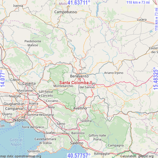
Santa Colomba II GPS coordinates[2]
41° 6' 34.128" North, 14° 46' 48.432" East
| Map corner | latitude | longitude |
|---|---|---|
| Upper-left | 41.63711°, | 14.077° |
| Center: | 41.10948°, | 14.78012° |
| Lower-right: | 40.57757°, | 15.48325° |
| Map W x H: | 117.8×117.8 km | = 73.2×73.2mi |
| max Lat: | 47.04031° ⇑77.5% North |
| Santa Colomba II: | 41.10948° |
| min Lat: | ⇓22.5% South 35.50142° |
| min Long | Santa Colomba I | max Long |
| 6.69888° | 14.78012° | 18.48682° |
| W 85.2%⇐ | ⇒14.8% E |
Elevation
Elevation of Santa Colomba II is 139 m = 456 ft, and this is 167.7 m = 550 ft below average elevation for this country.
| Max E: |
2085 m = 6841 ft | 63.3% |
| Avg. | 306.7 m = 1006 ft | |
| Santa Colomba II | 139 m = 456 ft | |
Min E: |
-4 m = -13 ft | 36.7% |
See also: Italy elevation on elevation.city.
Geographical zone
Santa Colomba II is located in North temperate zone (between Tropic of Cancer and the Arctic Circle). Distance of this Northern Tropic circle is 1965 km =1221 mi to South.| Distance of | km | miles | from Santa Colomba II |
|---|---|---|---|
| North Pole | 5436.1 | 3377.8 | to North |
| Arctic Circle | 2830.2 | 1758.6 | to North |
| Tropic Cancer | 1965 | 1221 | to South |
| Equator | 4570.9 | 2840.2 | to South |


Nearby cities:
15 places around Santa Colomba II: (largest is in red/bold)
• Apollosa
7.3 km =4.5 mi,  254°
254°
• Beltiglio-San Giovanni
5.7 km =3.5 mi,  203°
203°
• Benevento
2.4 km =1.5 mi,  356°
356°
• Castelpoto
7.5 km =4.7 mi,  297°
297°
• Ceppaloni
7.3 km =4.5 mi,  192°
192°
• Cesine
7.4 km =4.6 mi,  111°
111°
• Chianche
7.1 km =4.4 mi,  173°
173°
• Iannassi-Bosco Perrotta
5 km =3.1 mi, 114°
• Maccoli-Perrillo
3.2 km =2 mi,  138°
138°
• Pastene
4.1 km =2.5 mi, 137°
• San Giorgio del Sannio
7.6 km =4.7 mi,  126°
126°
• San Leucio del Sannio-Cavuoti
4.3 km =2.7 mi,  205°
205°
• San Martino Sannita
6.7 km =4.2 mi, 136°
• San Nicola Manfredi
5.3 km =3.3 mi, 135°
• Sant'Angelo A Cupolo
4.9 km =3 mi,  156°
156°
Sources, notices
• [Note1] Compared only with cities in Italy existing in our database
• [Src1] Map data: © OpenStreetMap contributors (CC-BY-SA)
• [Src2] Other city data from geonames.org with taken over terms of usage.
• [Src3] Geographical zone / Annual Mean Temperature by Robert A. Rohde @ Wikipedia
