Benevento geodata
Benevento (Campania) is a seat of a second-order administrative division; located in Italy in Europe/Rome (GMT+2) time zone. With population of 48,931 people, there are 121 cities with bigger population in this country. Compared to other cities in Italy, 77.3% of cities are located further ↑North; 85.2% of cities are located further ←West and 61.2% of cities have higher elevation than Benevento. Note1


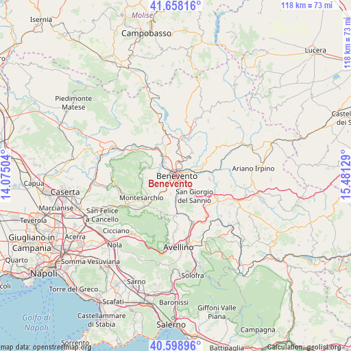
Benevento GPS coordinates[2]
41° 7' 50.52" North, 14° 46' 41.376" East
| Map corner | latitude | longitude |
|---|---|---|
| Upper-left | 41.65816°, | 14.07504° |
| Center: | 41.1307°, | 14.77816° |
| Lower-right: | 40.59896°, | 15.48129° |
| Map W x H: | 117.8×117.8 km | = 73.2×73.2mi |
| max Lat: | 47.04031° ⇑77.3% North |
| Benevento: | 41.1307° |
| min Lat: | ⇓22.7% South 35.50142° |
| min Long | Benevento | max Long |
| 6.69888° | 14.77816° | 18.48682° |
| W 85.2%⇐ | ⇒14.8% E |
Elevation
Elevation of Benevento is 154 m = 505 ft, and this is 152.7 m = 501 ft below average elevation for this country.
| Max E: |
2085 m = 6841 ft | 61.2% |
| Avg. | 306.7 m = 1006 ft | |
| Benevento | 154 m = 505 ft | |
Min E: |
-4 m = -13 ft | 38.8% |
See also: Benevento elevation on elevation.city.
Geographical zone
Benevento is located in North temperate zone (between Tropic of Cancer and the Arctic Circle). Distance of this Northern Tropic circle is 1967.4 km =1222.5 mi to South.| Distance of | km | miles | from Benevento |
|---|---|---|---|
| North Pole | 5433.8 | 3376.4 | to North |
| Arctic Circle | 2827.9 | 1757.2 | to North |
| Tropic Cancer | 1967.4 | 1222.5 | to South |
| Equator | 4573.3 | 2841.7 | to South |


Nearby cities:
15 places around Benevento: (largest is in red/bold)
• Apollosa
8.1 km =5 mi,  237°
237°
• Beltiglio-San Giovanni
7.9 km =4.9 mi,  195°
195°
• Castelpoto
6.6 km =4.1 mi,  279°
279°
• Cesine
8.7 km =5.4 mi,  125°
125°
• Chianche
9.4 km =5.8 mi,  174°
174°
• Iannassi-Bosco Perrotta
6.4 km =4 mi, 133°
• Maccoli-Perrillo
5.3 km =3.3 mi,  154°
154°
• Pastene
6.1 km =3.8 mi, 151°
• Pietrelcina
9.4 km =5.8 mi,  35°
35°
• San Giorgio del Sannio
9.4 km =5.8 mi,  137°
137°
• San Leucio del Sannio-Cavuoti
6.5 km =4 mi, 195°
• San Martino Sannita
8.7 km =5.4 mi, 146°
• San Nicola Manfredi
7.3 km =4.5 mi, 147°
• Sant'Angelo A Cupolo
7.2 km =4.5 mi,  162°
162°
• Santa Colomba II
2.4 km =1.5 mi,  176°
176°
Sources, notices
• [Note1] Compared only with cities in Italy existing in our database
• [Src1] Map data: © OpenStreetMap contributors (CC-BY-SA)
• [Src2] Other city data from geonames.org with taken over terms of usage.
• [Src3] Geographical zone / Annual Mean Temperature by Robert A. Rohde @ Wikipedia
