Pasta geodata
Pasta (Piedmont) is a populated place; located in Italy in Europe/Rome (GMT+2) time zone. With population of 1,986 people, there are 4184 cities with bigger population in this country. Compared to other cities in Italy, 60.2% of cities are located further ↓South; 97.4% of cities are located further →East and 55.1% of cities have lower elevation than Pasta. Note1


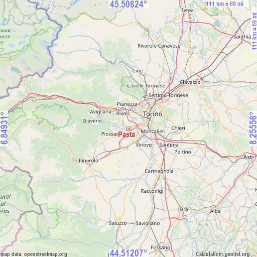
Pasta GPS coordinates[2]
45° 0' 40.716" North, 7° 33' 8.748" East
| Map corner | latitude | longitude |
|---|---|---|
| Upper-left | 45.50624°, | 6.84931° |
| Center: | 45.01131°, | 7.55243° |
| Lower-right: | 44.51207°, | 8.25556° |
| Map W x H: | 110.5×110.5 km | = 68.7×68.7mi |
| max Lat: | 47.04031° ⇑39.8% North |
| Pasta: | 45.01131° |
| min Lat: | ⇓60.2% South 35.50142° |
| min Long | Pasta | max Long |
| 6.69888° | 7.55243° | 18.48682° |
| W 2.6%⇐ | ⇒97.4% E |
Elevation
Elevation of Pasta is 266 m = 873 ft, and this is 40.7 m = 134 ft below average elevation for this country.
| Max E: |
2085 m = 6841 ft | 44.9% |
| Avg. | 306.7 m = 1006 ft | |
| Pasta | 266 m = 873 ft | |
Min E: |
-4 m = -13 ft | 55.1% |
See also: Italy elevation on elevation.city.
Geographical zone
Pasta is located in North temperate zone (between Tropic of Cancer and the Arctic Circle). Distance of this North polar circle is 2396.4 km =1489.1 mi to North.| Distance of | km | miles | from Pasta |
|---|---|---|---|
| North Pole | 5002.3 | 3108.3 | to North |
| Arctic Circle | 2396.4 | 1489.1 | to North |
| Tropic Cancer | 2398.9 | 1490.6 | to South |
| Equator | 5004.8 | 3109.8 | to South |


Nearby cities:
15 places around Pasta: (largest is in red/bold)
• Beinasco
3 km =1.9 mi,  60°
60°
• Borgo Melano
2 km =1.2 mi,  75°
75°
• Bruino
5.9 km =3.7 mi,  274°
274°
• Candiolo
6.9 km =4.3 mi,  148°
148°
• Corbiglia
6.2 km =3.9 mi,  312°
312°
• Fornaci
4.1 km =2.5 mi, 62°
• Garino
6.6 km =4.1 mi,  129°
129°
• Gerbido
6.1 km =3.8 mi,  52°
52°
• Gerbole
3.8 km =2.4 mi,  252°
252°
• Gerbole-Zucche
4 km =2.5 mi,  224°
224°
• Grugliasco
6.4 km =4 mi,  19°
19°
• Orbassano
1.3 km =0.8 mi,  239°
239°
• Rivalta di Torino
3.5 km =2.2 mi, 313°
• Tetti Neirotti
4.8 km =3 mi,  348°
348°
• Volvera
7.1 km =4.4 mi,  207°
207°
Sources, notices
• [Note1] Compared only with cities in Italy existing in our database
• [Src1] Map data: © OpenStreetMap contributors (CC-BY-SA)
• [Src2] Other city data from geonames.org with taken over terms of usage.
• [Src3] Geographical zone / Annual Mean Temperature by Robert A. Rohde @ Wikipedia
