Bettole geodata
Bettole (Lombardy) is a populated place; located in Italy in Europe/Rome (GMT+2) time zone. With population of 560 people, there are 9347 cities with bigger population in this country. Compared to other cities in Italy, 73.3% of cities are located further ↓South; 65.3% of cities are located further →East and 65.5% of cities have higher elevation than Bettole. Note1


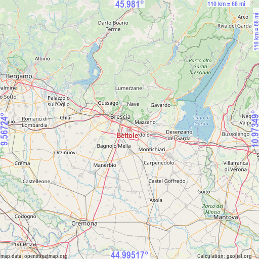
Bettole GPS coordinates[2]
45° 29' 24.864" North, 10° 16' 13.296" East
| Map corner | latitude | longitude |
|---|---|---|
| Upper-left | 45.981°, | 9.56724° |
| Center: | 45.49024°, | 10.27036° |
| Lower-right: | 44.99517°, | 10.97349° |
| Map W x H: | 109.6×109.6 km | = 68.1×68.1mi |
| max Lat: | 47.04031° ⇑26.7% North |
| Bettole: | 45.49024° |
| min Lat: | ⇓73.3% South 35.50142° |
| min Long | Bettole | max Long |
| 6.69888° | 10.27036° | 18.48682° |
| W 34.7%⇐ | ⇒65.3% E |
Elevation
Elevation of Bettole is 125 m = 410 ft, and this is 181.7 m = 596 ft below average elevation for this country.
| Max E: |
2085 m = 6841 ft | 65.5% |
| Avg. | 306.7 m = 1006 ft | |
| Bettole | 125 m = 410 ft | |
Min E: |
-4 m = -13 ft | 34.5% |
See also: Italy elevation on elevation.city.
Geographical zone
Bettole is located in North temperate zone (between Tropic of Cancer and the Arctic Circle). Distance of this North polar circle is 2343.1 km =1455.9 mi to North.| Distance of | km | miles | from Bettole |
|---|---|---|---|
| North Pole | 4949 | 3075.2 | to North |
| Arctic Circle | 2343.1 | 1455.9 | to North |
| Tropic Cancer | 2452.1 | 1523.7 | to South |
| Equator | 5058 | 3142.9 | to South |


Nearby cities:
15 places around Bettole: (largest is in red/bold)
• Borgosatollo
2.8 km =1.7 mi,  237°
237°
• Botticino
5.4 km =3.4 mi,  35°
35°
• Brescia
6.6 km =4.1 mi,  319°
319°
• Buffalora-Bettole
0.8 km =0.5 mi,  27°
27°
• Capodimonte
2.6 km =1.6 mi,  188°
188°
• Castenedolo
2.4 km =1.5 mi,  137°
137°
• Flero
7.3 km =4.5 mi,  263°
263°
• Folzano
5 km =3.1 mi,  277°
277°
• Mazzano
7.3 km =4.5 mi,  62°
62°
• Molinetto
6.9 km =4.3 mi,  86°
86°
• Montirone
5.9 km =3.7 mi,  213°
213°
• Poncarale
7.8 km =4.8 mi,  245°
245°
• Rezzato
4.4 km =2.7 mi, 56°
• San Zeno Naviglio
4.1 km =2.5 mi,  273°
273°
• Zerbino
8.2 km =5.1 mi, 272°
Sources, notices
• [Note1] Compared only with cities in Italy existing in our database
• [Src1] Map data: © OpenStreetMap contributors (CC-BY-SA)
• [Src2] Other city data from geonames.org with taken over terms of usage.
• [Src3] Geographical zone / Annual Mean Temperature by Robert A. Rohde @ Wikipedia
