Fiumara geodata
Fiumara (Sicily) is a populated place; located in Italy in Europe/Rome (GMT+2) time zone. With population of 560 people, there are 9347 cities with bigger population in this country. Compared to other cities in Italy, 95.3% of cities are located further ↑North; 86% of cities are located further ←West and 76.1% of cities have higher elevation than Fiumara. Note1


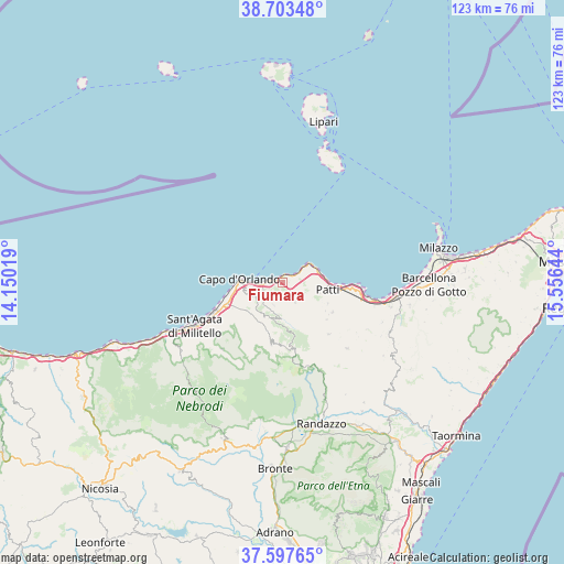
Fiumara GPS coordinates[2]
38° 9' 9.576" North, 14° 51' 11.916" East
| Map corner | latitude | longitude |
|---|---|---|
| Upper-left | 38.70348°, | 14.15019° |
| Center: | 38.15266°, | 14.85331° |
| Lower-right: | 37.59765°, | 15.55644° |
| Map W x H: | 123×123 km | = 76.4×76.4mi |
| max Lat: | 47.04031° ⇑95.3% North |
| Fiumara: | 38.15266° |
| min Lat: | ⇓4.7% South 35.50142° |
| min Long | Fiumara | max Long |
| 6.69888° | 14.85331° | 18.48682° |
| W 86%⇐ | ⇒14% E |
Elevation
Elevation of Fiumara is 69 m = 226 ft, and this is 237.7 m = 780 ft below average elevation for this country.
| Max E: |
2085 m = 6841 ft | 76.1% |
| Avg. | 306.7 m = 1006 ft | |
| Fiumara | 69 m = 226 ft | |
Min E: |
-4 m = -13 ft | 23.9% |
See also: Italy elevation on elevation.city.
Geographical zone
Fiumara is located in North temperate zone (between Tropic of Cancer and the Arctic Circle). Distance of this Northern Tropic circle is 1636.3 km =1016.7 mi to South.| Distance of | km | miles | from Fiumara |
|---|---|---|---|
| North Pole | 5764.9 | 3582.1 | to North |
| Arctic Circle | 3159 | 1962.9 | to North |
| Tropic Cancer | 1636.3 | 1016.7 | to South |
| Equator | 4242.2 | 2636 | to South |


Nearby cities:
15 places around Fiumara: (largest is in red/bold)
• Brolo
2.2 km =1.4 mi,  280°
280°
• Capo d'Orlando
10.6 km =6.6 mi,  263°
263°
• Castell'Umberto
8.4 km =5.2 mi,  208°
208°
• Cresta
8 km =5 mi,  253°
253°
• Ficarra
5.3 km =3.3 mi,  202°
202°
• Gioiosa Marea
4.7 km =2.9 mi,  59°
59°
• Gliaca
1.3 km =0.8 mi,  337°
337°
• Montagnareale
8.5 km =5.3 mi,  105°
105°
• Naso
6.7 km =4.2 mi,  239°
239°
• Patti
9.7 km =6 mi,  93°
93°
• Piraino
1.2 km =0.7 mi,  35°
35°
• San Giorgio
8.5 km =5.3 mi,  78°
78°
• Sant'Angelo di Brolo
5 km =3.1 mi,  147°
147°
• Sfaranda
10.7 km =6.6 mi,  190°
190°
• Sinagra
7.9 km =4.9 mi,  182°
182°
Sources, notices
• [Note1] Compared only with cities in Italy existing in our database
• [Src1] Map data: © OpenStreetMap contributors (CC-BY-SA)
• [Src2] Other city data from geonames.org with taken over terms of usage.
• [Src3] Geographical zone / Annual Mean Temperature by Robert A. Rohde @ Wikipedia
