Agnone geodata
Agnone (Campania) is a populated place; located in Italy in Europe/Rome (GMT+2) time zone. With population of 551 people, there are 9440 cities with bigger population in this country. Compared to other cities in Italy, 86.3% of cities are located further ↑North; 87.1% of cities are located further ←West and 95.9% of cities have higher elevation than Agnone. Note1


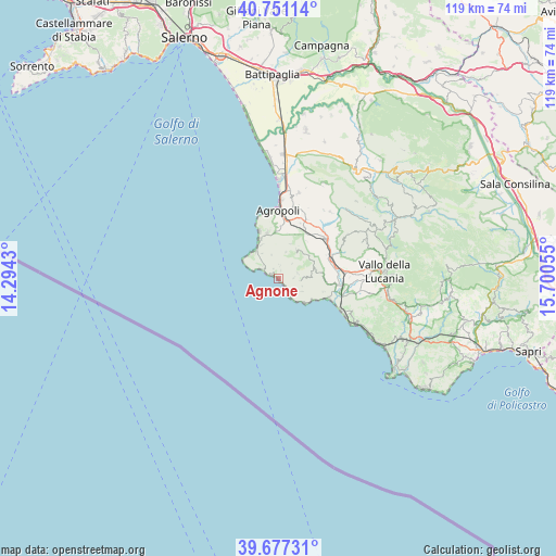
Agnone GPS coordinates[2]
40° 12' 58.86" North, 14° 59' 50.712" East
| Map corner | latitude | longitude |
|---|---|---|
| Upper-left | 40.75114°, | 14.2943° |
| Center: | 40.21635°, | 14.99742° |
| Lower-right: | 39.67731°, | 15.70055° |
| Map W x H: | 119.4×119.4 km | = 74.2×74.2mi |
| max Lat: | 47.04031° ⇑86.3% North |
| Agnone: | 40.21635° |
| min Lat: | ⇓13.7% South 35.50142° |
| min Long | Agnone | max Long |
| 6.69888° | 14.99742° | 18.48682° |
| W 87.1%⇐ | ⇒12.9% E |
Elevation
Elevation of Agnone is 7 m = 23 ft, and this is 299.7 m = 983 ft below average elevation for this country.
| Max E: |
2085 m = 6841 ft | 95.9% |
| Avg. | 306.7 m = 1006 ft | |
| Agnone | 7 m = 23 ft | |
Min E: |
-4 m = -13 ft | 4.1% |
See also: Italy elevation on elevation.city.
Geographical zone
Agnone is located in North temperate zone (between Tropic of Cancer and the Arctic Circle). Distance of this Northern Tropic circle is 1865.7 km =1159.3 mi to South.| Distance of | km | miles | from Agnone |
|---|---|---|---|
| North Pole | 5535.4 | 3439.5 | to North |
| Arctic Circle | 2929.5 | 1820.3 | to North |
| Tropic Cancer | 1865.7 | 1159.3 | to South |
| Equator | 4471.6 | 2778.5 | to South |


Nearby cities:
15 places around Agnone: (largest is in red/bold)
• Acciaroli
4.7 km =2.9 mi,  147°
147°
• Casal Velino
10.1 km =6.3 mi,  106°
106°
• Castellabate
8.1 km =5 mi,  335°
335°
• Laureana Cilento
10.1 km =6.3 mi,  20°
20°
• Lustra
10 km =6.2 mi,  36°
36°
• Montecorice
2.3 km =1.4 mi,  332°
332°
• Omignano
8.2 km =5.1 mi,  63°
63°
• Perdifumo
5.9 km =3.7 mi, 16°
• Pollica
5.8 km =3.6 mi,  119°
119°
• San Marco
7.5 km =4.7 mi,  318°
318°
• San Mauro Cilento
4.2 km =2.6 mi,  74°
74°
• Santa Maria
9.8 km =6.1 mi, 337°
• Serramezzana
4.3 km =2.7 mi, 43°
• Sessa Cilento
8.2 km =5.1 mi,  54°
54°
• Stella Cilento
8.3 km =5.2 mi,  78°
78°
Sources, notices
• [Note1] Compared only with cities in Italy existing in our database
• [Src1] Map data: © OpenStreetMap contributors (CC-BY-SA)
• [Src2] Other city data from geonames.org with taken over terms of usage.
• [Src3] Geographical zone / Annual Mean Temperature by Robert A. Rohde @ Wikipedia
