Fengo geodata
Fengo (Lombardy) is a populated place; located in Italy in Europe/Rome (GMT+2) time zone. With population of 535 people, there are 9594 cities with bigger population in this country. Compared to other cities in Italy, 64.6% of cities are located further ↓South; 68.9% of cities are located further →East and 79.3% of cities have higher elevation than Fengo. Note1
Administrative division(s):
- Level 1: Lombardy
- Level 2: Provincia di Cremona
- Level 3: Acquanegra Cremonese


Fengo GPS coordinates[2]
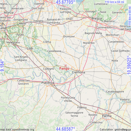
45° 11' 1.032" North, 9° 53' 13.632" East
| Map corner | latitude | longitude |
|---|---|---|
| Upper-left | 45.67705°, | 9.184° |
| Center: | 45.18362°, | 9.88712° |
| Lower-right: | 44.68587°, | 10.59025° |
| Map W x H: | 110.2×110.2 km | = 68.5×68.5mi |
| max Lat: | 47.04031° ⇑35.4% North |
| Fengo: | 45.18362° |
| min Lat: | ⇓64.6% South 35.50142° |
| min Long | Fengo | max Long |
| 6.69888° | 9.88712° | 18.48682° |
| W 31.1%⇐ | ⇒68.9% E |
Elevation
Elevation of Fengo is 53 m = 174 ft, and this is 253.7 m = 832 ft below average elevation for this country.
| Max E: |
2085 m = 6841 ft | 79.3% |
| Avg. | 306.7 m = 1006 ft | |
| Fengo | 53 m = 174 ft | |
Min E: |
-4 m = -13 ft | 20.7% |
See also: Italy elevation on elevation.city.
Geographical zone
Fengo is located in North temperate zone (between Tropic of Cancer and the Arctic Circle). Distance of this North polar circle is 2377.2 km =1477.1 mi to North.| Distance of | km | miles | from Fengo |
|---|---|---|---|
| North Pole | 4983.1 | 3096.4 | to North |
| Arctic Circle | 2377.2 | 1477.1 | to North |
| Tropic Cancer | 2418 | 1502.5 | to South |
| Equator | 5023.9 | 3121.7 | to South |


Nearby cities:
15 places around Fengo: (largest is in red/bold)
• Acquanegra Cremonese
1.7 km =1.1 mi,  170°
170°
• Annicco
6.7 km =4.2 mi,  354°
354°
• Casanova del Morbasco
6.4 km =4 mi,  111°
111°
• Costa Sant'Abramo
6.5 km =4 mi, 106°
• Crotta d'Adda
3.6 km =2.2 mi,  220°
220°
• Grumello Cremonese
2.1 km =1.3 mi,  303°
303°
• Maccastorna
4.8 km =3 mi,  211°
211°
• Paderno Ponchielli
6.9 km =4.3 mi,  28°
28°
• Pizzighettone
7.8 km =4.8 mi,  272°
272°
• Regona
5.8 km =3.6 mi,  294°
294°
• Roggione
6.2 km =3.9 mi, 270°
• Santa Maria dei Sabbioni
7.7 km =4.8 mi,  330°
330°
• Sesto Cremonese
2.3 km =1.4 mi, 112°
• Sesto ed Uniti
2.3 km =1.4 mi, 110°
• Spinadesco
4.9 km =3 mi,  141°
141°
Sources, notices
• [Note1] Compared only with cities in Italy existing in our database
• [Src1] Map data: © OpenStreetMap contributors (CC-BY-SA)
• [Src2] Other city data from geonames.org with taken over terms of usage.
• [Src3] Geographical zone / Annual Mean Temperature by Robert A. Rohde @ Wikipedia
