Pizzighettone geodata
Pizzighettone (Lombardy) is a seat of a third-order administrative division; located in Italy in Europe/Rome (GMT+2) time zone. With population of 4,205 people, there are 2281 cities with bigger population in this country. Compared to other cities in Italy, 64.6% of cities are located further ↓South; 69.9% of cities are located further →East and 81.2% of cities have higher elevation than Pizzighettone. Note1


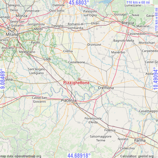
Pizzighettone GPS coordinates[2]
45° 11' 12.84" North, 9° 47' 16.116" East
| Map corner | latitude | longitude |
|---|---|---|
| Upper-left | 45.6803°, | 9.08469° |
| Center: | 45.1869°, | 9.78781° |
| Lower-right: | 44.68918°, | 10.49094° |
| Map W x H: | 110.2×110.2 km | = 68.5×68.5mi |
| max Lat: | 47.04031° ⇑35.4% North |
| Pizzighettone: | 45.1869° |
| min Lat: | ⇓64.6% South 35.50142° |
| min Long | Pizzighettone | max Long |
| 6.69888° | 9.78781° | 18.48682° |
| W 30.1%⇐ | ⇒69.9% E |
Elevation
Elevation of Pizzighettone is 45 m = 148 ft, and this is 261.7 m = 859 ft below average elevation for this country.
| Max E: |
2085 m = 6841 ft | 81.2% |
| Avg. | 306.7 m = 1006 ft | |
| Pizzighettone | 45 m = 148 ft | |
Min E: |
-4 m = -13 ft | 18.8% |
See also: Italy elevation on elevation.city.
Geographical zone
Pizzighettone is located in North temperate zone (between Tropic of Cancer and the Arctic Circle). Distance of this North polar circle is 2376.9 km =1476.9 mi to North.| Distance of | km | miles | from Pizzighettone |
|---|---|---|---|
| North Pole | 4982.7 | 3096.1 | to North |
| Arctic Circle | 2376.9 | 1476.9 | to North |
| Tropic Cancer | 2418.4 | 1502.7 | to South |
| Equator | 5024.3 | 3122 | to South |


Nearby cities:
15 places around Pizzighettone: (largest is in red/bold)
• Camairago
5.2 km =3.2 mi,  293°
293°
• Cavacurta
3.6 km =2.2 mi,  275°
275°
• Codogno
7.3 km =4.5 mi,  247°
247°
• Corno Giovine
6.3 km =3.9 mi,  201°
201°
• Cornovecchio
5.7 km =3.5 mi,  170°
170°
• Crotta d'Adda
6.2 km =3.9 mi,  119°
119°
• Formigara
4.2 km =2.6 mi,  341°
341°
• Grumello Cremonese
6.1 km =3.8 mi,  82°
82°
• Maccastorna
6.9 km =4.3 mi,  130°
130°
• Maleo
3 km =1.9 mi,  221°
221°
• Regona
3.2 km =2 mi,  50°
50°
• Roggione
1.6 km =1 mi,  102°
102°
• San Bassano
6.5 km =4 mi,  15°
15°
• San Fiorano
7.6 km =4.7 mi, 224°
• Santa Maria dei Sabbioni
7.5 km =4.7 mi,  32°
32°
Sources, notices
• [Note1] Compared only with cities in Italy existing in our database
• [Src1] Map data: © OpenStreetMap contributors (CC-BY-SA)
• [Src2] Other city data from geonames.org with taken over terms of usage.
• [Src3] Geographical zone / Annual Mean Temperature by Robert A. Rohde @ Wikipedia
