Regona geodata
Regona (Lombardy) is a populated place; located in Italy in Europe/Rome (GMT+2) time zone. With population of 675 people, there are 8459 cities with bigger population in this country. Compared to other cities in Italy, 65.1% of cities are located further ↓South; 69.7% of cities are located further →East and 80.1% of cities have higher elevation than Regona. Note1


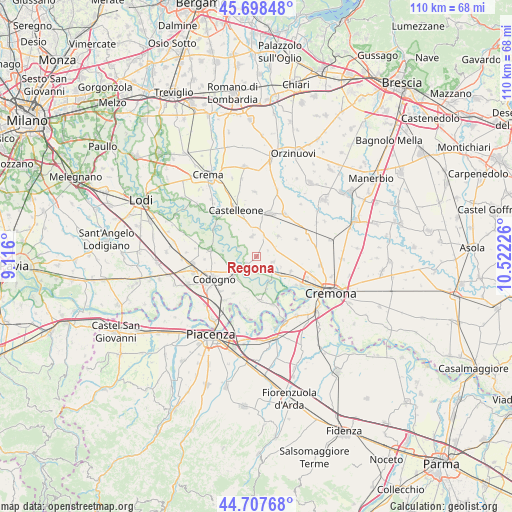
Regona GPS coordinates[2]
45° 12' 18.864" North, 9° 49' 8.868" East
| Map corner | latitude | longitude |
|---|---|---|
| Upper-left | 45.69848°, | 9.116° |
| Center: | 45.20524°, | 9.81913° |
| Lower-right: | 44.70768°, | 10.52226° |
| Map W x H: | 110.2×110.2 km | = 68.5×68.5mi |
| max Lat: | 47.04031° ⇑34.9% North |
| Regona: | 45.20524° |
| min Lat: | ⇓65.1% South 35.50142° |
| min Long | Regona | max Long |
| 6.69888° | 9.81913° | 18.48682° |
| W 30.3%⇐ | ⇒69.7% E |
Elevation
Elevation of Regona is 49 m = 161 ft, and this is 257.7 m = 845 ft below average elevation for this country.
| Max E: |
2085 m = 6841 ft | 80.1% |
| Avg. | 306.7 m = 1006 ft | |
| Regona | 49 m = 161 ft | |
Min E: |
-4 m = -13 ft | 19.9% |
See also: Italy elevation on elevation.city.
Geographical zone
Regona is located in North temperate zone (between Tropic of Cancer and the Arctic Circle). Distance of this North polar circle is 2374.8 km =1475.6 mi to North.| Distance of | km | miles | from Regona |
|---|---|---|---|
| North Pole | 4980.7 | 3094.9 | to North |
| Arctic Circle | 2374.8 | 1475.6 | to North |
| Tropic Cancer | 2420.4 | 1504 | to South |
| Equator | 5026.4 | 3123.3 | to South |


Nearby cities:
15 places around Regona: (largest is in red/bold)
• Acquanegra Cremonese
6.9 km =4.3 mi,  125°
125°
• Annicco
6.3 km =3.9 mi,  47°
47°
• Camairago
7.2 km =4.5 mi,  270°
270°
• Cappella Cantone
4.8 km =3 mi,  18°
18°
• Cavacurta
6.3 km =3.9 mi,  254°
254°
• Crotta d'Adda
5.9 km =3.7 mi,  150°
150°
• Fengo
5.8 km =3.6 mi,  114°
114°
• Formigara
4.3 km =2.7 mi,  297°
297°
• Grumello Cremonese
3.8 km =2.4 mi, 109°
• Maccastorna
7.1 km =4.4 mi,  156°
156°
• Maleo
6.2 km =3.9 mi,  225°
225°
• Pizzighettone
3.2 km =2 mi, 230°
• Roggione
2.6 km =1.6 mi,  201°
201°
• San Bassano
4.4 km =2.7 mi,  350°
350°
• Santa Maria dei Sabbioni
4.6 km =2.9 mi, 20°
Sources, notices
• [Note1] Compared only with cities in Italy existing in our database
• [Src1] Map data: © OpenStreetMap contributors (CC-BY-SA)
• [Src2] Other city data from geonames.org with taken over terms of usage.
• [Src3] Geographical zone / Annual Mean Temperature by Robert A. Rohde @ Wikipedia
