Borgaccio geodata
Borgaccio (The Marches) is a populated place; located in Italy in Europe/Rome (GMT+2) time zone. With population of 518 people, there are 9748 cities with bigger population in this country. Compared to other cities in Italy, 57.6% of cities are located further ↑North; 67.3% of cities are located further ←West and 76.5% of cities have higher elevation than Borgaccio. Note1
Administrative division(s):
- Level 1: The Marches
- Level 2: Provincia di Pesaro e Urbino
- Level 3: Colli al Metauro


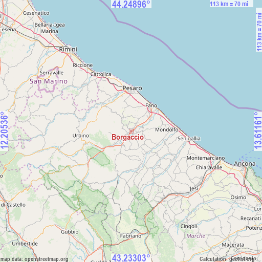
Borgaccio GPS coordinates[2]
43° 44' 35.34" North, 12° 54' 30.528" East
| Map corner | latitude | longitude |
|---|---|---|
| Upper-left | 44.24896°, | 12.20536° |
| Center: | 43.74315°, | 12.90848° |
| Lower-right: | 43.23303°, | 13.61161° |
| Map W x H: | 113×113 km | = 70.2×70.2mi |
| max Lat: | 47.04031° ⇑57.6% North |
| Borgaccio: | 43.74315° |
| min Lat: | ⇓42.4% South 35.50142° |
| min Long | Borgaccio | max Long |
| 6.69888° | 12.90848° | 18.48682° |
| W 67.3%⇐ | ⇒32.7% E |
Elevation
Elevation of Borgaccio is 67 m = 220 ft, and this is 239.7 m = 786 ft below average elevation for this country.
| Max E: |
2085 m = 6841 ft | 76.5% |
| Avg. | 306.7 m = 1006 ft | |
| Borgaccio | 67 m = 220 ft | |
Min E: |
-4 m = -13 ft | 23.5% |
See also: Italy elevation on elevation.city.
Geographical zone
Borgaccio is located in North temperate zone (between Tropic of Cancer and the Arctic Circle). Distance of this Northern Tropic circle is 2257.9 km =1403 mi to South.| Distance of | km | miles | from Borgaccio |
|---|---|---|---|
| North Pole | 5143.3 | 3195.9 | to North |
| Arctic Circle | 2537.4 | 1576.7 | to North |
| Tropic Cancer | 2257.9 | 1403 | to South |
| Equator | 4863.8 | 3022.2 | to South |


Nearby cities:
15 places around Borgaccio: (largest is in red/bold)
• Calcinelli
1.5 km =0.9 mi,  36°
36°
• Cartoceto
3.2 km =2 mi,  321°
321°
• Cuccurano
6.9 km =4.3 mi, 36°
• Lucrezia
4.2 km =2.6 mi, 37°
• Mombaroccio
7.2 km =4.5 mi, 323°
• Montefelcino
6.1 km =3.8 mi,  261°
261°
• Montemaggiore al Metauro
3 km =1.9 mi,  103°
103°
• Orciano di Pesaro
7.9 km =4.9 mi,  139°
139°
• Piagge
4.9 km =3 mi, 102°
• Saltara
1.3 km =0.8 mi, 322°
• San Giorgio di Pesaro
6.2 km =3.9 mi,  111°
111°
• Sant'Ippolito
7.5 km =4.7 mi,  200°
200°
• Serrungarina
2.7 km =1.7 mi,  278°
278°
• Tavernelle
2.4 km =1.5 mi,  238°
238°
• Villanova
2.2 km =1.4 mi, 101°
Sources, notices
• [Note1] Compared only with cities in Italy existing in our database
• [Src1] Map data: © OpenStreetMap contributors (CC-BY-SA)
• [Src2] Other city data from geonames.org with taken over terms of usage.
• [Src3] Geographical zone / Annual Mean Temperature by Robert A. Rohde @ Wikipedia
