Cuccurano geodata
Cuccurano (The Marches) is a populated place; located in Italy in Europe/Rome (GMT+2) time zone. With population of 3,469 people, there are 2701 cities with bigger population in this country. Compared to other cities in Italy, 57.1% of cities are located further ↑North; 67.8% of cities are located further ←West and 80.5% of cities have higher elevation than Cuccurano. Note1
Administrative division(s):
- Level 1: The Marches
- Level 2: Provincia di Pesaro e Urbino
- Level 3: Fano


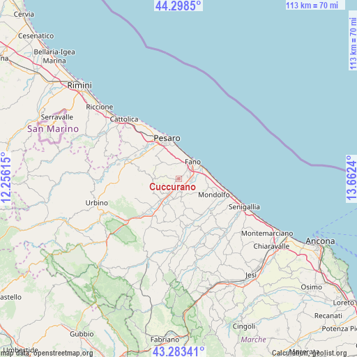
Cuccurano GPS coordinates[2]
43° 47' 35.196" North, 12° 57' 33.372" East
| Map corner | latitude | longitude |
|---|---|---|
| Upper-left | 44.2985°, | 12.25615° |
| Center: | 43.79311°, | 12.95927° |
| Lower-right: | 43.28341°, | 13.6624° |
| Map W x H: | 112.9×112.9 km | = 70.2×70.2mi |
| max Lat: | 47.04031° ⇑57.1% North |
| Cuccurano: | 43.79311° |
| min Lat: | ⇓42.9% South 35.50142° |
| min Long | Cuccurano | max Long |
| 6.69888° | 12.95927° | 18.48682° |
| W 67.8%⇐ | ⇒32.2% E |
Elevation
Elevation of Cuccurano is 47 m = 154 ft, and this is 259.7 m = 852 ft below average elevation for this country.
| Max E: |
2085 m = 6841 ft | 80.5% |
| Avg. | 306.7 m = 1006 ft | |
| Cuccurano | 47 m = 154 ft | |
Min E: |
-4 m = -13 ft | 19.5% |
See also: Italy elevation on elevation.city.
Geographical zone
Cuccurano is located in North temperate zone (between Tropic of Cancer and the Arctic Circle). Distance of this Northern Tropic circle is 2263.4 km =1406.4 mi to South.| Distance of | km | miles | from Cuccurano |
|---|---|---|---|
| North Pole | 5137.7 | 3192.4 | to North |
| Arctic Circle | 2531.8 | 1573.2 | to North |
| Tropic Cancer | 2263.4 | 1406.4 | to South |
| Equator | 4869.3 | 3025.6 | to South |


Nearby cities:
15 places around Cuccurano: (largest is in red/bold)
• Bellocchi
3.7 km =2.3 mi,  85°
85°
• Borgaccio
6.9 km =4.3 mi,  216°
216°
• Calcinelli
5.4 km =3.4 mi, 216°
• Cartoceto
6.8 km =4.2 mi,  243°
243°
• Centinarola
4.9 km =3 mi,  29°
29°
• Fano
7 km =4.3 mi,  41°
41°
• Fenile
5.4 km =3.4 mi,  7°
7°
• Lucrezia
2.7 km =1.7 mi,  214°
214°
• Montemaggiore al Metauro
6.4 km =4 mi,  190°
190°
• Piagge
6.6 km =4.1 mi,  173°
173°
• Rosciano
4.2 km =2.6 mi,  51°
51°
• Saltara
6.6 km =4.1 mi,  227°
227°
• San Giorgio di Pesaro
8 km =5 mi, 168°
• Villagrande
8 km =5 mi,  280°
280°
• Villanova
6.3 km =3.9 mi,  197°
197°
Sources, notices
• [Note1] Compared only with cities in Italy existing in our database
• [Src1] Map data: © OpenStreetMap contributors (CC-BY-SA)
• [Src2] Other city data from geonames.org with taken over terms of usage.
• [Src3] Geographical zone / Annual Mean Temperature by Robert A. Rohde @ Wikipedia
