Montemaggiore al Metauro geodata
Montemaggiore al Metauro (The Marches) is a seat of a third-order administrative division; located in Italy in Europe/Rome (GMT+2) time zone. With population of 269 people, there are 10805 cities with bigger population in this country. Compared to other cities in Italy, 57.7% of cities are located further ↑North; 67.6% of cities are located further ←West and 60.2% of cities have higher elevation than Montemaggiore al Metauro. Note1
Administrative division(s):
- Level 1: The Marches
- Level 2: Provincia di Pesaro e Urbino
- Level 3: Colli al Metauro
Current local time in Montemaggiore al Metauro:
12:07 AM, ThursdayDifference from your time zone: hours


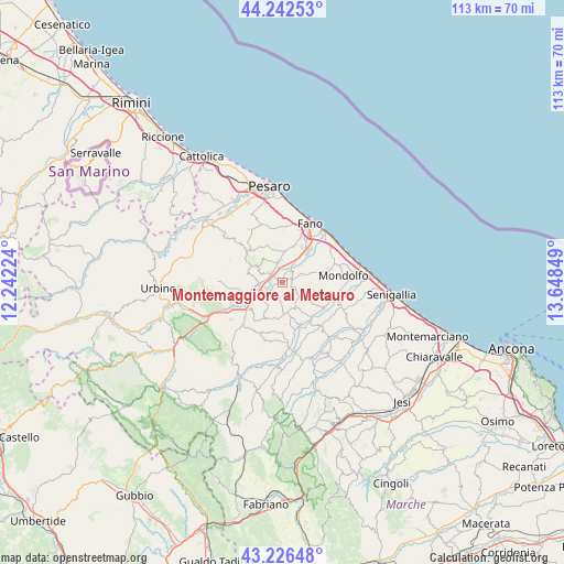
Montemaggiore al Metauro GPS coordinates[2]
43° 44' 11.976" North, 12° 56' 43.296" East
| Map corner | latitude | longitude |
|---|---|---|
| Upper-left | 44.24253°, | 12.24224° |
| Center: | 43.73666°, | 12.94536° |
| Lower-right: | 43.22648°, | 13.64849° |
| Map W x H: | 113×113 km | = 70.2×70.2mi |
| max Lat: | 47.04031° ⇑57.7% North |
| Montemaggiore al Metauro: | 43.73666° |
| min Lat: | ⇓42.3% South 35.50142° |
| min Long | Montemaggiore a | max Long |
| 6.69888° | 12.94536° | 18.48682° |
| W 67.6%⇐ | ⇒32.4% E |
Elevation
Elevation of Montemaggiore al Metauro is 162 m = 531 ft, and this is 144.7 m = 475 ft below average elevation for this country.
| Max E: |
2085 m = 6841 ft | 60.2% |
| Avg. | 306.7 m = 1006 ft | |
| Montemaggiore al Metauro | 162 m = 531 ft | |
Min E: |
-4 m = -13 ft | 39.8% |
See also: Italy elevation on elevation.city.
Geographical zone
Montemaggiore al Metauro is located in North temperate zone (between Tropic of Cancer and the Arctic Circle). Distance of this Northern Tropic circle is 2257.1 km =1402.5 mi to South.| Distance of | km | miles | from Montemaggiore al Metauro |
|---|---|---|---|
| North Pole | 5144 | 3196.3 | to North |
| Arctic Circle | 2538.1 | 1577.1 | to North |
| Tropic Cancer | 2257.1 | 1402.5 | to South |
| Equator | 4863.1 | 3021.8 | to South |


Nearby cities:
15 places around Montemaggiore al Metauro: (largest is in red/bold)
• Barchi
7.2 km =4.5 mi,  190°
190°
• Bellocchi
8.2 km =5.1 mi,  36°
36°
• Borgaccio
3 km =1.9 mi,  283°
283°
• Calcinelli
2.8 km =1.7 mi,  312°
312°
• Cartoceto
5.9 km =3.7 mi,  302°
302°
• Cuccurano
6.4 km =4 mi,  10°
10°
• Lucrezia
4.1 km =2.5 mi,  353°
353°
• Mondavio
7.1 km =4.4 mi,  166°
166°
• Orciano di Pesaro
5.7 km =3.5 mi,  157°
157°
• Piagge
1.9 km =1.2 mi,  99°
99°
• Saltara
4.2 km =2.6 mi, 295°
• San Giorgio di Pesaro
3.2 km =2 mi,  119°
119°
• Serrungarina
5.8 km =3.6 mi, 281°
• Tavernelle
5 km =3.1 mi,  264°
264°
• Villanova
0.9 km =0.6 mi,  289°
289°
Sources, notices
• [Note1] Compared only with cities in Italy existing in our database
• [Src1] Map data: © OpenStreetMap contributors (CC-BY-SA)
• [Src2] Other city data from geonames.org with taken over terms of usage.
• [Src3] Geographical zone / Annual Mean Temperature by Robert A. Rohde @ Wikipedia
