Coriano geodata
Coriano (Veneto) is a populated place; located in Italy in Europe/Rome (GMT+2) time zone. With population of 515 people, there are 9776 cities with bigger population in this country. Compared to other cities in Italy, 66.8% of cities are located further ↓South; 53.3% of cities are located further →East and 89% of cities have higher elevation than Coriano. Note1


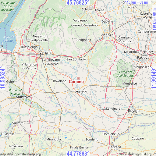
Coriano GPS coordinates[2]
45° 16' 32.232" North, 11° 17' 18.096" East
| Map corner | latitude | longitude |
|---|---|---|
| Upper-left | 45.76825°, | 10.58524° |
| Center: | 45.27562°, | 11.28836° |
| Lower-right: | 44.77868°, | 11.99149° |
| Map W x H: | 110×110 km | = 68.4×68.4mi |
| max Lat: | 47.04031° ⇑33.2% North |
| Coriano: | 45.27562° |
| min Lat: | ⇓66.8% South 35.50142° |
| min Long | Coriano | max Long |
| 6.69888° | 11.28836° | 18.48682° |
| W 46.7%⇐ | ⇒53.3% E |
Elevation
Elevation of Coriano is 20 m = 66 ft, and this is 286.7 m = 941 ft below average elevation for this country.
| Max E: |
2085 m = 6841 ft | 89% |
| Avg. | 306.7 m = 1006 ft | |
| Coriano | 20 m = 66 ft | |
Min E: |
-4 m = -13 ft | 11% |
See also: Italy elevation on elevation.city.
Geographical zone
Coriano is located in North temperate zone (between Tropic of Cancer and the Arctic Circle). Distance of this North polar circle is 2367 km =1470.8 mi to North.| Distance of | km | miles | from Coriano |
|---|---|---|---|
| North Pole | 4972.9 | 3090 | to North |
| Arctic Circle | 2367 | 1470.8 | to North |
| Tropic Cancer | 2428.3 | 1508.9 | to South |
| Equator | 5034.2 | 3128.1 | to South |


Nearby cities:
15 places around Coriano: (largest is in red/bold)
• Albaredo d'Adige
4.8 km =3 mi,  350°
350°
• Angiari
5.9 km =3.7 mi,  188°
188°
• Bonavigo
2 km =1.2 mi,  199°
199°
• Caselle
5.8 km =3.6 mi,  90°
90°
• Gallese
6.6 km =4.1 mi,  149°
149°
• Isola Rizza
7.2 km =4.5 mi,  284°
284°
• Michellorie
2 km =1.2 mi,  52°
52°
• Minerbe
7 km =4.3 mi,  134°
134°
• Ronco All'Adige
7.9 km =4.9 mi,  329°
329°
• Roverchiara
3.5 km =2.2 mi,  255°
255°
• Roverchiaretta
2.9 km =1.8 mi,  228°
228°
• San Gregorio
7.5 km =4.7 mi,  6°
6°
• San Pietro di Morubio
6.1 km =3.8 mi, 232°
• Tombazosana
5 km =3.1 mi, 330°
• Veronella
6.1 km =3.8 mi,  28°
28°
Sources, notices
• [Note1] Compared only with cities in Italy existing in our database
• [Src1] Map data: © OpenStreetMap contributors (CC-BY-SA)
• [Src2] Other city data from geonames.org with taken over terms of usage.
• [Src3] Geographical zone / Annual Mean Temperature by Robert A. Rohde @ Wikipedia
