Ceredello geodata
Ceredello (Veneto) is a populated place; located in Italy in Europe/Rome (GMT+2) time zone. With population of 511 people, there are 9811 cities with bigger population in this country. Compared to other cities in Italy, 76.7% of cities are located further ↓South; 59.9% of cities are located further →East and 52.8% of cities have lower elevation than Ceredello. Note1


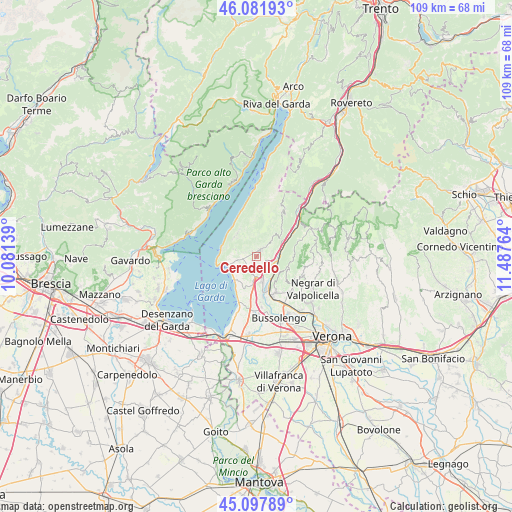
Ceredello GPS coordinates[2]
45° 35' 31.452" North, 10° 47' 4.236" East
| Map corner | latitude | longitude |
|---|---|---|
| Upper-left | 46.08193°, | 10.08139° |
| Center: | 45.59207°, | 10.78451° |
| Lower-right: | 45.09789°, | 11.48764° |
| Map W x H: | 109.4×109.4 km | = 68×68mi |
| max Lat: | 47.04031° ⇑23.3% North |
| Ceredello: | 45.59207° |
| min Lat: | ⇓76.7% South 35.50142° |
| min Long | Ceredello | max Long |
| 6.69888° | 10.78451° | 18.48682° |
| W 40.1%⇐ | ⇒59.9% E |
Elevation
Elevation of Ceredello is 252 m = 827 ft, and this is 54.7 m = 179 ft below average elevation for this country.
| Max E: |
2085 m = 6841 ft | 47.2% |
| Avg. | 306.7 m = 1006 ft | |
| Ceredello | 252 m = 827 ft | |
Min E: |
-4 m = -13 ft | 52.8% |
See also: Italy elevation on elevation.city.
Geographical zone
Ceredello is located in North temperate zone (between Tropic of Cancer and the Arctic Circle). Distance of this North polar circle is 2331.8 km =1448.9 mi to North.| Distance of | km | miles | from Ceredello |
|---|---|---|---|
| North Pole | 4937.7 | 3068.1 | to North |
| Arctic Circle | 2331.8 | 1448.9 | to North |
| Tropic Cancer | 2463.4 | 1530.7 | to South |
| Equator | 5069.4 | 3150 | to South |


Nearby cities:
15 places around Ceredello: (largest is in red/bold)
• Affi
4.4 km =2.7 mi,  178°
178°
• Albarè Stazione
3.1 km =1.9 mi,  225°
225°
• Bardolino
6.9 km =4.3 mi,  215°
215°
• Caprino Veronese
1.6 km =1 mi,  30°
30°
• Cavajon Veronese
5.9 km =3.7 mi,  190°
190°
• Costermano
3.6 km =2.2 mi,  259°
259°
• Dolcè
5.4 km =3.4 mi,  79°
79°
• Garda
5.4 km =3.4 mi,  254°
254°
• Pesina Spezie
1.6 km =1 mi,  315°
315°
• Pesine Bisse
2.6 km =1.6 mi,  287°
287°
• Rivoli Veronese
3 km =1.9 mi,  135°
135°
• San Zeno
6.3 km =3.9 mi, 317°
• San Zeno di Montagna
6.5 km =4 mi, 321°
• Torri del Benaco
7.9 km =4.9 mi,  284°
284°
• Volargne
6.7 km =4.2 mi,  156°
156°
Sources, notices
• [Note1] Compared only with cities in Italy existing in our database
• [Src1] Map data: © OpenStreetMap contributors (CC-BY-SA)
• [Src2] Other city data from geonames.org with taken over terms of usage.
• [Src3] Geographical zone / Annual Mean Temperature by Robert A. Rohde @ Wikipedia
