Affi geodata
Affi (Veneto) is a seat of a third-order administrative division; located in Italy in Europe/Rome (GMT+2) time zone. With population of 1,733 people, there are 4603 cities with bigger population in this country. Compared to other cities in Italy, 75.4% of cities are located further ↓South; 59.8% of cities are located further →East and 56.3% of cities have higher elevation than Affi. Note1


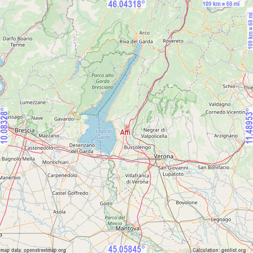
Affi GPS coordinates[2]
45° 33' 10.692" North, 10° 47' 11.04" East
| Map corner | latitude | longitude |
|---|---|---|
| Upper-left | 46.04318°, | 10.08328° |
| Center: | 45.55297°, | 10.7864° |
| Lower-right: | 45.05845°, | 11.48953° |
| Map W x H: | 109.5×109.5 km | = 68×68mi |
| max Lat: | 47.04031° ⇑24.6% North |
| Affi: | 45.55297° |
| min Lat: | ⇓75.4% South 35.50142° |
| min Long | Affi | max Long |
| 6.69888° | 10.7864° | 18.48682° |
| W 40.2%⇐ | ⇒59.8% E |
Elevation
Elevation of Affi is 193 m = 633 ft, and this is 113.7 m = 373 ft below average elevation for this country.
| Max E: |
2085 m = 6841 ft | 56.3% |
| Avg. | 306.7 m = 1006 ft | |
| Affi | 193 m = 633 ft | |
Min E: |
-4 m = -13 ft | 43.7% |
See also: Italy elevation on elevation.city.
Geographical zone
Affi is located in North temperate zone (between Tropic of Cancer and the Arctic Circle). Distance of this North polar circle is 2336.2 km =1451.6 mi to North.| Distance of | km | miles | from Affi |
|---|---|---|---|
| North Pole | 4942 | 3070.8 | to North |
| Arctic Circle | 2336.2 | 1451.6 | to North |
| Tropic Cancer | 2459.1 | 1528 | to South |
| Equator | 5065 | 3147.2 | to South |


Nearby cities:
15 places around Affi: (largest is in red/bold)
• Albarè Stazione
3.2 km =2 mi,  312°
312°
• Bardolino
4.4 km =2.7 mi,  252°
252°
• Calmasino
4.4 km =2.7 mi,  216°
216°
• Caprino Veronese
5.8 km =3.6 mi,  6°
6°
• Cavajon Veronese
1.9 km =1.2 mi, 220°
• Ceredello
4.4 km =2.7 mi,  358°
358°
• Costermano
5.2 km =3.2 mi, 314°
• Garda
6.1 km =3.8 mi,  298°
298°
• Pesina Spezie
5.6 km =3.5 mi,  347°
347°
• Pesine Bisse
5.8 km =3.6 mi,  332°
332°
• Rivoli Veronese
2.9 km =1.8 mi,  42°
42°
• Sant'Ambrogio di Valpollicella
5.3 km =3.3 mi,  132°
132°
• Santa Lucia
6.4 km =4 mi,  153°
153°
• Sega
3.9 km =2.4 mi,  161°
161°
• Volargne
3.1 km =1.9 mi, 125°
Sources, notices
• [Note1] Compared only with cities in Italy existing in our database
• [Src1] Map data: © OpenStreetMap contributors (CC-BY-SA)
• [Src2] Other city data from geonames.org with taken over terms of usage.
• [Src3] Geographical zone / Annual Mean Temperature by Robert A. Rohde @ Wikipedia
