Volargne geodata
Volargne (Veneto) is a populated place; located in Italy in Europe/Rome (GMT+2) time zone. With population of 1,230 people, there are 5865 cities with bigger population in this country. Compared to other cities in Italy, 74.8% of cities are located further ↓South; 59.5% of cities are located further →East and 68.1% of cities have higher elevation than Volargne. Note1


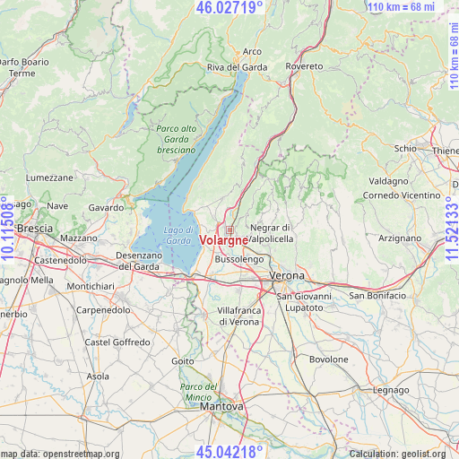
Volargne GPS coordinates[2]
45° 32' 12.624" North, 10° 49' 5.52" East
| Map corner | latitude | longitude |
|---|---|---|
| Upper-left | 46.02719°, | 10.11508° |
| Center: | 45.53684°, | 10.8182° |
| Lower-right: | 45.04218°, | 11.52133° |
| Map W x H: | 109.5×109.5 km | = 68×68mi |
| max Lat: | 47.04031° ⇑25.2% North |
| Volargne: | 45.53684° |
| min Lat: | ⇓74.8% South 35.50142° |
| min Long | Volargne | max Long |
| 6.69888° | 10.8182° | 18.48682° |
| W 40.5%⇐ | ⇒59.5% E |
Elevation
Elevation of Volargne is 108 m = 354 ft, and this is 198.7 m = 652 ft below average elevation for this country.
| Max E: |
2085 m = 6841 ft | 68.1% |
| Avg. | 306.7 m = 1006 ft | |
| Volargne | 108 m = 354 ft | |
Min E: |
-4 m = -13 ft | 31.9% |
See also: Italy elevation on elevation.city.
Geographical zone
Volargne is located in North temperate zone (between Tropic of Cancer and the Arctic Circle). Distance of this North polar circle is 2338 km =1452.8 mi to North.| Distance of | km | miles | from Volargne |
|---|---|---|---|
| North Pole | 4943.8 | 3071.9 | to North |
| Arctic Circle | 2338 | 1452.8 | to North |
| Tropic Cancer | 2457.3 | 1526.9 | to South |
| Equator | 5063.2 | 3146.1 | to South |


Nearby cities:
15 places around Volargne: (largest is in red/bold)
• Affi
3.1 km =1.9 mi,  305°
305°
• Albarè Stazione
6.3 km =3.9 mi, 309°
• Bardolino
6.7 km =4.2 mi,  274°
274°
• Bure
4.3 km =2.7 mi,  105°
105°
• Calmasino
5.4 km =3.4 mi,  251°
251°
• Cavajon Veronese
3.7 km =2.3 mi,  275°
275°
• Ceredello
6.7 km =4.2 mi,  336°
336°
• Fumane
5.3 km =3.3 mi,  84°
84°
• Ospedaletto
4 km =2.5 mi,  152°
152°
• Pastrengo
4.8 km =3 mi,  198°
198°
• Rivoli Veronese
4 km =2.5 mi,  352°
352°
• San Pietro in Cariano
5.7 km =3.5 mi, 112°
• Sant'Ambrogio di Valpollicella
2.3 km =1.4 mi,  141°
141°
• Santa Lucia
4 km =2.5 mi,  174°
174°
• Sega
2.2 km =1.4 mi,  213°
213°
Sources, notices
• [Note1] Compared only with cities in Italy existing in our database
• [Src1] Map data: © OpenStreetMap contributors (CC-BY-SA)
• [Src2] Other city data from geonames.org with taken over terms of usage.
• [Src3] Geographical zone / Annual Mean Temperature by Robert A. Rohde @ Wikipedia
