Coassolo geodata
Coassolo (Piedmont) is a seat of a third-order administrative division; located in Italy in Europe/Rome (GMT+2) time zone. With population of 353 people, there are 10466 cities with bigger population in this country. Compared to other cities in Italy, 67.4% of cities are located further ↓South; 98% of cities are located further →East and 89% of cities have lower elevation than Coassolo. Note1


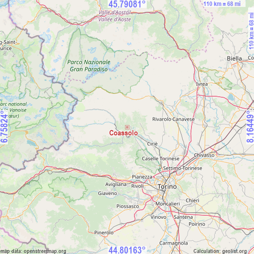
Coassolo GPS coordinates[2]
45° 17' 54.168" North, 7° 27' 40.896" East
| Map corner | latitude | longitude |
|---|---|---|
| Upper-left | 45.79081°, | 6.75824° |
| Center: | 45.29838°, | 7.46136° |
| Lower-right: | 44.80163°, | 8.16449° |
| Map W x H: | 110×110 km | = 68.4×68.4mi |
| max Lat: | 47.04031° ⇑32.6% North |
| Coassolo: | 45.29838° |
| min Lat: | ⇓67.4% South 35.50142° |
| min Long | Coassolo | max Long |
| 6.69888° | 7.46136° | 18.48682° |
| W 2%⇐ | ⇒98% E |
Elevation
Elevation of Coassolo is 693 m = 2274 ft, and this is 386.3 m = 1267 ft above average elevation for this country.
| Max E: |
2085 m = 6841 ft | 11% |
| Coassolo | 693 m 2274 ft | |
| Avg. | 306.7 m = 1006 ft | |
Min E: |
-4 m = -13 ft | 89% |
See also: Italy elevation on elevation.city.
Geographical zone
Coassolo is located in North temperate zone (between Tropic of Cancer and the Arctic Circle). Distance of this North polar circle is 2364.5 km =1469.2 mi to North.| Distance of | km | miles | from Coassolo |
|---|---|---|---|
| North Pole | 4970.4 | 3088.5 | to North |
| Arctic Circle | 2364.5 | 1469.2 | to North |
| Tropic Cancer | 2430.8 | 1510.4 | to South |
| Equator | 5036.7 | 3129.7 | to South |


Nearby cities:
15 places around Coassolo: (largest is in red/bold)
• Balangero
5.5 km =3.4 mi,  125°
125°
• Benne
7.1 km =4.4 mi,  97°
97°
• Cafasse
7.1 km =4.4 mi,  140°
140°
• Cantoira
7.6 km =4.7 mi,  307°
307°
• Ceres
5.9 km =3.7 mi,  286°
286°
• Coassolo Torinese
0.1 km =0.1 mi,  226°
226°
• Corio
5.8 km =3.6 mi,  74°
74°
• Germagnano
4 km =2.5 mi,  171°
171°
• La Villa
4.2 km =2.6 mi,  214°
214°
• Lanzo Torinese
2.9 km =1.8 mi,  145°
145°
• Mathi
7.9 km =4.9 mi, 127°
• Mezzenile
5.2 km =3.2 mi,  265°
265°
• Monastero di Lanzo
1.7 km =1.1 mi,  282°
282°
• Pessinetto
3.8 km =2.4 mi,  250°
250°
• Traves
4.1 km =2.5 mi,  215°
215°
Sources, notices
• [Note1] Compared only with cities in Italy existing in our database
• [Src1] Map data: © OpenStreetMap contributors (CC-BY-SA)
• [Src2] Other city data from geonames.org with taken over terms of usage.
• [Src3] Geographical zone / Annual Mean Temperature by Robert A. Rohde @ Wikipedia
