Ghiaie geodata
Ghiaie (Lombardy) is a populated place; located in Italy in Europe/Rome (GMT+2) time zone. With population of 1,620 people, there are 4849 cities with bigger population in this country. Compared to other cities in Italy, 80.4% of cities are located further ↓South; 72.2% of cities are located further →East and 55.3% of cities have higher elevation than Ghiaie. Note1


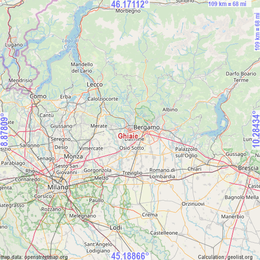
Ghiaie GPS coordinates[2]
45° 40' 55.38" North, 9° 34' 52.356" East
| Map corner | latitude | longitude |
|---|---|---|
| Upper-left | 46.17112°, | 8.87809° |
| Center: | 45.68205°, | 9.58121° |
| Lower-right: | 45.18866°, | 10.28434° |
| Map W x H: | 109.2×109.2 km | = 67.9×67.9mi |
| max Lat: | 47.04031° ⇑19.6% North |
| Ghiaie: | 45.68205° |
| min Lat: | ⇓80.4% South 35.50142° |
| min Long | Ghiaie | max Long |
| 6.69888° | 9.58121° | 18.48682° |
| W 27.8%⇐ | ⇒72.2% E |
Elevation
Elevation of Ghiaie is 200 m = 656 ft, and this is 106.7 m = 350 ft below average elevation for this country.
| Max E: |
2085 m = 6841 ft | 55.3% |
| Avg. | 306.7 m = 1006 ft | |
| Ghiaie | 200 m = 656 ft | |
Min E: |
-4 m = -13 ft | 44.7% |
See also: Italy elevation on elevation.city.
Geographical zone
Ghiaie is located in North temperate zone (between Tropic of Cancer and the Arctic Circle). Distance of this North polar circle is 2321.8 km =1442.7 mi to North.| Distance of | km | miles | from Ghiaie |
|---|---|---|---|
| North Pole | 4927.7 | 3061.9 | to North |
| Arctic Circle | 2321.8 | 1442.7 | to North |
| Tropic Cancer | 2473.4 | 1536.9 | to South |
| Equator | 5079.4 | 3156.2 | to South |


Nearby cities:
15 places around Ghiaie: (largest is in red/bold)
• Bonate Sopra
1.7 km =1.1 mi,  269°
269°
• Bonate Sotto
2.3 km =1.4 mi,  228°
228°
• Brembate di Sopra
3.9 km =2.4 mi,  357°
357°
• Curno
2.3 km =1.4 mi,  70°
70°
• Dalmine
4.1 km =2.5 mi,  151°
151°
• Lallio
4.3 km =2.7 mi,  119°
119°
• Madone
4.3 km =2.7 mi,  214°
214°
• Mapello
4 km =2.5 mi,  328°
328°
• Mozzo
2.8 km =1.7 mi,  49°
49°
• Ponte San Pietro
2.8 km =1.7 mi,  15°
15°
• Presezzo
1.4 km =0.9 mi,  322°
322°
• Roncola
1.4 km =0.9 mi,  137°
137°
• Terno d'Isola
3.9 km =2.4 mi,  275°
275°
• Treviolo
2.6 km =1.6 mi,  111°
111°
• Valtrighe
3.8 km =2.4 mi,  293°
293°
Sources, notices
• [Note1] Compared only with cities in Italy existing in our database
• [Src1] Map data: © OpenStreetMap contributors (CC-BY-SA)
• [Src2] Other city data from geonames.org with taken over terms of usage.
• [Src3] Geographical zone / Annual Mean Temperature by Robert A. Rohde @ Wikipedia
