Dalmine geodata
Dalmine (Lombardy) is a seat of a third-order administrative division; located in Italy in Europe/Rome (GMT+2) time zone. With population of 22,881 people, there are 374 cities with bigger population in this country. Compared to other cities in Italy, 79% of cities are located further ↓South; 71.9% of cities are located further →East and 54.6% of cities have higher elevation than Dalmine. Note1


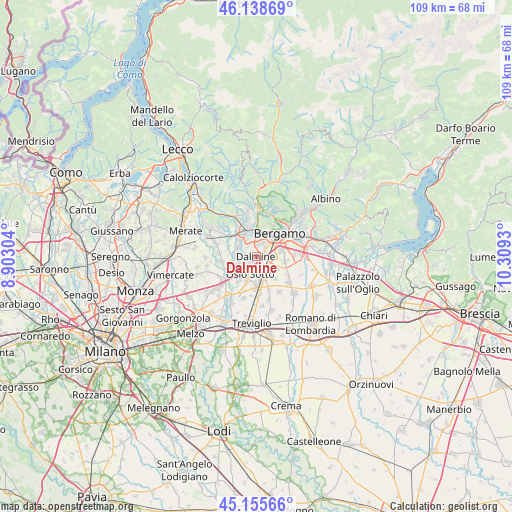
Dalmine GPS coordinates[2]
45° 38' 57.588" North, 9° 36' 22.212" East
| Map corner | latitude | longitude |
|---|---|---|
| Upper-left | 46.13869°, | 8.90304° |
| Center: | 45.64933°, | 9.60617° |
| Lower-right: | 45.15566°, | 10.3093° |
| Map W x H: | 109.3×109.3 km | = 67.9×67.9mi |
| max Lat: | 47.04031° ⇑21% North |
| Dalmine: | 45.64933° |
| min Lat: | ⇓79% South 35.50142° |
| min Long | Dalmine | max Long |
| 6.69888° | 9.60617° | 18.48682° |
| W 28.1%⇐ | ⇒71.9% E |
Elevation
Elevation of Dalmine is 205 m = 673 ft, and this is 101.7 m = 334 ft below average elevation for this country.
| Max E: |
2085 m = 6841 ft | 54.6% |
| Avg. | 306.7 m = 1006 ft | |
| Dalmine | 205 m = 673 ft | |
Min E: |
-4 m = -13 ft | 45.4% |
See also: Italy elevation on elevation.city.
Geographical zone
Dalmine is located in North temperate zone (between Tropic of Cancer and the Arctic Circle). Distance of this North polar circle is 2325.4 km =1444.9 mi to North.| Distance of | km | miles | from Dalmine |
|---|---|---|---|
| North Pole | 4931.3 | 3064.2 | to North |
| Arctic Circle | 2325.4 | 1444.9 | to North |
| Tropic Cancer | 2469.8 | 1534.7 | to South |
| Equator | 5075.7 | 3153.9 | to South |


Nearby cities:
15 places around Dalmine: (largest is in red/bold)
• Bonate Sopra
5.1 km =3.2 mi,  314°
314°
• Bonate Sotto
4.2 km =2.6 mi,  299°
299°
• Comun Nuovo
5.2 km =3.2 mi,  124°
124°
• Curno
4.4 km =2.7 mi,  2°
2°
• Filago
4.1 km =2.5 mi,  251°
251°
• Ghiaie
4.1 km =2.5 mi,  331°
331°
• Lallio
2.3 km =1.4 mi,  49°
49°
• Levate
3 km =1.9 mi,  152°
152°
• Madone
4.4 km =2.7 mi,  271°
271°
• Marne
4.7 km =2.9 mi,  232°
232°
• Osio Sopra
2.8 km =1.7 mi,  216°
216°
• Osio Sotto
3.9 km =2.4 mi,  199°
199°
• Roncola
2.8 km =1.7 mi,  338°
338°
• Stezzano
3.6 km =2.2 mi,  89°
89°
• Treviolo
2.7 km =1.7 mi,  9°
9°
Sources, notices
• [Note1] Compared only with cities in Italy existing in our database
• [Src1] Map data: © OpenStreetMap contributors (CC-BY-SA)
• [Src2] Other city data from geonames.org with taken over terms of usage.
• [Src3] Geographical zone / Annual Mean Temperature by Robert A. Rohde @ Wikipedia
