Lallio geodata
Lallio (Lombardy) is a seat of a third-order administrative division; located in Italy in Europe/Rome (GMT+2) time zone. With population of 4,124 people, there are 2326 cities with bigger population in this country. Compared to other cities in Italy, 79.6% of cities are located further ↓South; 71.5% of cities are located further →East and 53.6% of cities have higher elevation than Lallio. Note1


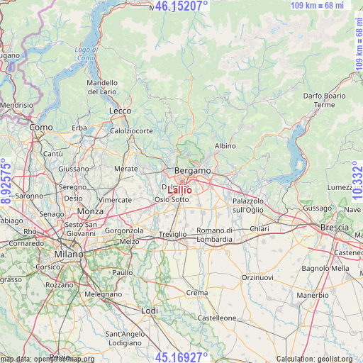
Lallio GPS coordinates[2]
45° 39' 46.188" North, 9° 37' 43.932" East
| Map corner | latitude | longitude |
|---|---|---|
| Upper-left | 46.15207°, | 8.92575° |
| Center: | 45.66283°, | 9.62887° |
| Lower-right: | 45.16927°, | 10.332° |
| Map W x H: | 109.3×109.3 km | = 67.9×67.9mi |
| max Lat: | 47.04031° ⇑20.4% North |
| Lallio: | 45.66283° |
| min Lat: | ⇓79.6% South 35.50142° |
| min Long | Lallio | max Long |
| 6.69888° | 9.62887° | 18.48682° |
| W 28.5%⇐ | ⇒71.5% E |
Elevation
Elevation of Lallio is 212 m = 696 ft, and this is 94.7 m = 311 ft below average elevation for this country.
| Max E: |
2085 m = 6841 ft | 53.6% |
| Avg. | 306.7 m = 1006 ft | |
| Lallio | 212 m = 696 ft | |
Min E: |
-4 m = -13 ft | 46.4% |
See also: Italy elevation on elevation.city.
Geographical zone
Lallio is located in North temperate zone (between Tropic of Cancer and the Arctic Circle). Distance of this North polar circle is 2323.9 km =1444 mi to North.| Distance of | km | miles | from Lallio |
|---|---|---|---|
| North Pole | 4929.8 | 3063.2 | to North |
| Arctic Circle | 2323.9 | 1444 | to North |
| Tropic Cancer | 2471.3 | 1535.6 | to South |
| Equator | 5077.2 | 3154.8 | to South |


Nearby cities:
15 places around Lallio: (largest is in red/bold)
• Azzano San Paolo
3.5 km =2.2 mi,  98°
98°
• Bergamo
4.7 km =2.9 mi,  38°
38°
• Bonate Sotto
5.5 km =3.4 mi,  276°
276°
• Comun Nuovo
5.1 km =3.2 mi,  149°
149°
• Curno
3.3 km =2.1 mi,  331°
331°
• Dalmine
2.3 km =1.4 mi,  229°
229°
• Ghiaie
4.3 km =2.7 mi,  299°
299°
• Levate
4.2 km =2.6 mi,  185°
185°
• Mozzo
4.3 km =2.7 mi,  338°
338°
• Orio al Serio
5 km =3.1 mi,  74°
74°
• Osio Sopra
5.1 km =3.2 mi,  222°
222°
• Roncola
3 km =1.9 mi,  292°
292°
• Stezzano
2.3 km =1.4 mi,  129°
129°
• Treviolo
1.8 km =1.1 mi,  312°
312°
• Zanica
5 km =3.1 mi,  118°
118°
Sources, notices
• [Note1] Compared only with cities in Italy existing in our database
• [Src1] Map data: © OpenStreetMap contributors (CC-BY-SA)
• [Src2] Other city data from geonames.org with taken over terms of usage.
• [Src3] Geographical zone / Annual Mean Temperature by Robert A. Rohde @ Wikipedia
